


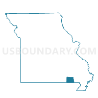
Varner Voting District, Ripley County, Missouri
About
Outline

Summary
| Unique Area Identifier | 609563 |
| Name | Varner Voting District |
| County | Ripley County |
| State | Missouri |
| Area (square miles) | 28.53 |
| Land Area (square miles) | 28.53 |
| Water Area (square miles) | 0.00 |
| % of Land Area | 100.00 |
| % of Water Area | 0.00 |
| Latitude of the Internal Point | 36.59074940 |
| Longtitude of the Internal Point | -90.68874630 |
Maps


Graphs
Select a template below for downloading or customizing gragh for Varner Voting District, Ripley County, Missouri


Neighbors
Neighoring Voting District (by Name) Neighboring Voting District on the Map
- Doniphan P1, Ripley County, MO
- Flatwoods/Johnson P2, Ripley County, MO
- Harris Voting District, Ripley County, MO
- Thomas Voting District, Ripley County, MO
- Washington Voting District, Ripley County, MO
Top 10 Neighboring County Subdivision (by Population) Neighboring County Subdivision on the Map
- Doniphan township, Ripley County, MO (5,656)
- Washington township, Ripley County, MO (989)
- Thomas township, Ripley County, MO (871)
- Harris township, Ripley County, MO (744)
- Varner township, Ripley County, MO (657)
- Flatwoods township, Ripley County, MO (650)