


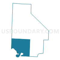
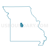
Webb Voting District, Morgan County, Missouri
About
Outline

Summary
| Unique Area Identifier | 609188 |
| Name | Webb Voting District |
| County | Morgan County |
| State | Missouri |
| Area (square miles) | 113.51 |
| Land Area (square miles) | 108.08 |
| Water Area (square miles) | 5.43 |
| % of Land Area | 95.22 |
| % of Water Area | 4.78 |
| Latitude of the Internal Point | 38.28431560 |
| Longtitude of the Internal Point | -92.95097640 |
Maps

Graphs
Select a template below for downloading or customizing gragh for Webb Voting District, Morgan County, Missouri


Neighbors
Neighoring Voting District (by Name) Neighboring Voting District on the Map
- Climax Springs Voting District, Camden County, MO
- Cole No. 1 Voting District, Benton County, MO
- East Williams Voting District, Benton County, MO
- Fairgrounds South Voting District, Morgan County, MO
- Gravois Mills Voting District, Morgan County, MO
- Laurie Voting District, Morgan County, MO
- North Union Voting District, Benton County, MO
- Stover South Voting District, Morgan County, MO
- Sunrise Beach 2 Voting District, Camden County, MO
- Versailles Voting District, Morgan County, MO
- Wilson Bend Voting District, Camden County, MO
Top 10 Neighboring County Subdivision (by Population) Neighboring County Subdivision on the Map
- Osage township, Morgan County, MO (6,175)
- Moreau township, Morgan County, MO (5,854)
- Jasper township, Camden County, MO (5,395)
- Adair township, Camden County, MO (5,062)
- Haw Creek township, Morgan County, MO (4,226)
- Williams township, Benton County, MO (3,179)
- Buffalo township, Morgan County, MO (2,112)
- Cole township, Benton County, MO (2,070)
- Union township, Benton County, MO (1,523)
Top 10 Neighboring Unified School District (by Population) Neighboring Unified School District on the Map
- Camdenton R-III School District, MO (31,430)
- Morgan County R-II School District, MO (11,110)
- Warsaw R-IX School District, MO (10,830)
- Morgan County R-I School District, MO (5,309)
- Cole Camp R-I School District, MO (5,082)
- Climax Springs R-IV School District, MO (2,850)
Top 10 Neighboring State Legislative District Lower Chamber (by Population) Neighboring State Legislative District Lower Chamber on the Map
- State House District 155, MO (41,624)
- State House District 116, MO (38,212)
- State House District 115, MO (37,008)
Top 10 Neighboring State Legislative District Upper Chamber (by Population) Neighboring State Legislative District Upper Chamber on the Map
- State Senate District 33, MO (184,118)
- State Senate District 6, MO (181,242)
- State Senate District 28, MO (177,259)
Top 10 Neighboring 111th Congressional District (by Population) Neighboring 111th Congressional District on the Map
Top 10 Neighboring Census Tract (by Population) Neighboring Census Tract on the Map
- Census Tract 4705, Morgan County, MO (5,204)
- Census Tract 4608, Benton County, MO (3,911)
- Census Tract 9507, Camden County, MO (3,677)
- Census Tract 4702, Morgan County, MO (3,572)
- Census Tract 4601, Benton County, MO (3,211)
- Census Tract 4704, Morgan County, MO (2,981)
- Census Tract 9512, Camden County, MO (2,482)
- Census Tract 4604, Benton County, MO (2,269)
Top 10 Neighboring 5-Digit ZIP Code Tabulation Area (by Population) Neighboring 5-Digit ZIP Code Tabulation Area on the Map
- 65084, MO (6,797)
- 65037, MO (4,938)
- 65078, MO (3,743)
- 65325, MO (3,171)
- 65338, MO (3,046)
- 65326, MO (1,996)
- 65324, MO (1,634)