


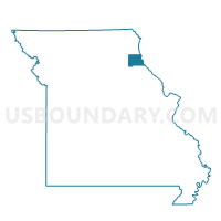
Warren Voting District, Marion County, Missouri
About
Outline

Summary
| Unique Area Identifier | 609077 |
| Name | Warren Voting District |
| County | Marion County |
| State | Missouri |
| Area (square miles) | 104.74 |
| Land Area (square miles) | 104.74 |
| Water Area (square miles) | 0.00 |
| % of Land Area | 100.00 |
| % of Water Area | 0.00 |
| Latitude of the Internal Point | 39.73045690 |
| Longtitude of the Internal Point | -91.74938710 |
Maps


Graphs
Select a template below for downloading or customizing gragh for Warren Voting District, Marion County, Missouri


Neighbors
Neighoring Voting District (by Name) Neighboring Voting District on the Map
- Hassard Voting District, Ralls County, MO
- Jackson Voting District, Shelby County, MO
- Monroe City Voting District, Marion County, MO
- Monroe City 1, 2, & 3/Indian Creek 4 Voting District, Monroe County, MO
- North Fork 5/Florida 18/Stoutsville 19 Voting District, Monroe County, MO
- North River Voting District, Shelby County, MO
- PACO Voting District, Marion County, MO
- Philadelphia Voting District, Marion County, MO
- Smileyville/Taylor Voting District, Marion County, MO
- West Ely Voting District, Marion County, MO
Top 10 Neighboring County Subdivision (by Population) Neighboring County Subdivision on the Map
- Liberty township, Marion County, MO (4,500)
- Monroe township, Monroe County, MO (2,355)
- Warren township, Marion County, MO (1,499)
- Fabius township, Marion County, MO (1,273)
- Union township, Marion County, MO (870)
- Saline township, Ralls County, MO (781)
- Jackson township, Shelby County, MO (460)
- South River township, Marion County, MO (369)
- Washington township, Monroe County, MO (296)
- North River township, Shelby County, MO (108)
Top 10 Neighboring Place (by Population) Neighboring Place on the Map
Top 10 Neighboring Unified School District (by Population) Neighboring Unified School District on the Map
- Palmyra R-I School District, MO (6,736)
- Monroe City R-I School District, MO (5,433)
- Shelby County R-IV School District, MO (4,317)
- Shelby County C-1 School District, MO (2,131)
- Marion County R-II School District, MO (1,278)
Top 10 Neighboring State Legislative District Lower Chamber (by Population) Neighboring State Legislative District Lower Chamber on the Map
- State House District 9, MO (36,616)
- State House District 6, MO (35,970)
- State House District 1, MO (33,818)
- State House District 8, MO (33,540)
Top 10 Neighboring State Legislative District Upper Chamber (by Population) Neighboring State Legislative District Upper Chamber on the Map
Top 10 Neighboring 111th Congressional District (by Population) Neighboring 111th Congressional District on the Map
Top 10 Neighboring Census Tract (by Population) Neighboring Census Tract on the Map
- Census Tract 9601, Marion County, MO (4,339)
- Census Tract 9601, Monroe County, MO (3,387)
- Census Tract 9602, Marion County, MO (3,240)
- Census Tract 4703, Ralls County, MO (3,123)
- Census Tract 4502, Shelby County, MO (2,672)
- Census Tract 4501, Shelby County, MO (1,880)