


Castor Voting District, Madison County, Missouri
About
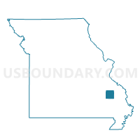
Outline

Summary
| Unique Area Identifier | 609056 |
| Name | Castor Voting District |
| County | Madison County |
| State | Missouri |
| Area (square miles) | 104.68 |
| Land Area (square miles) | 104.22 |
| Water Area (square miles) | 0.46 |
| % of Land Area | 99.56 |
| % of Water Area | 0.44 |
| Latitude of the Internal Point | 37.54399750 |
| Longtitude of the Internal Point | -90.24308920 |
Maps


Graphs
Select a template below for downloading or customizing gragh for Castor Voting District, Madison County, Missouri


Neighbors
Neighoring Voting District (by Name) Neighboring Voting District on the Map
- Central Voting District, Madison County, MO
- Fredericktown Ward 1, Madison County, MO
- Fredericktown Ward 2, Madison County, MO
- Fredericktown Ward 3, Madison County, MO
- Libertyville Voting District, St. Francois County, MO
- Marquand Voting District, Madison County, MO
- Patton Voting District, Bollinger County, MO
- St. Francis Voting District, Madison County, MO
- Yount Voting District, Perry County, MO
- Younts Store Voting District, Bollinger County, MO
Top 10 Neighboring County Subdivision (by Population) Neighboring County Subdivision on the Map
- St. Michael township, Madison County, MO (7,056)
- Liberty township, St. Francois County, MO (2,232)
- St. Marys township, Perry County, MO (1,708)
- Crooked Creek township, Bollinger County, MO (1,234)
- Castor township, Madison County, MO (1,082)
- Union township, Bollinger County, MO (1,058)
- Polk township, Madison County, MO (920)
- Mine La Motte township, Madison County, MO (843)
- Marquand township, Madison County, MO (764)
- Central township, Madison County, MO (487)
Top 10 Neighboring Place (by Population) Neighboring Place on the Map
- Fredericktown city, MO (3,985)
- Mine La Motte CDP, MO (348)
- Junction City village, MO (327)
- Cherokee Pass CDP, MO (235)
- Cobalt village, MO (226)
Top 10 Neighboring Unified School District (by Population) Neighboring Unified School District on the Map
- Farmington R-7 School District, MO (27,796)
- Perry County 32 School District, MO (17,763)
- Fredericktown R-I School District, MO (10,918)
- Meadow Heights R-II School District, MO (3,747)
- Marquand-Zion School District, MO (1,261)
Top 10 Neighboring State Legislative District Lower Chamber (by Population) Neighboring State Legislative District Lower Chamber on the Map
- State House District 106, MO (38,873)
- State House District 157, MO (37,900)
- State House District 156, MO (34,716)
Top 10 Neighboring State Legislative District Upper Chamber (by Population) Neighboring State Legislative District Upper Chamber on the Map
Top 10 Neighboring 111th Congressional District (by Population) Neighboring 111th Congressional District on the Map
Top 10 Neighboring Census Tract (by Population) Neighboring Census Tract on the Map
- Census Tract 9507, St. Francois County, MO (8,057)
- Census Tract 9602, Madison County, MO (5,243)
- Census Tract 4702, Perry County, MO (4,820)
- Census Tract 9501, Bollinger County, MO (4,691)
- Census Tract 9601, Madison County, MO (3,547)
- Census Tract 9603, Madison County, MO (3,436)