


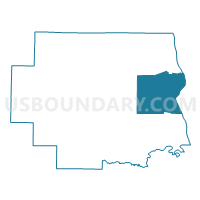
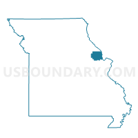
Foley Voting District, Lincoln County, Missouri
About
Outline

Summary
| Unique Area Identifier | 608970 |
| Name | Foley Voting District |
| County | Lincoln County |
| State | Missouri |
| Area (square miles) | 54.23 |
| Land Area (square miles) | 50.48 |
| Water Area (square miles) | 3.74 |
| % of Land Area | 93.10 |
| % of Water Area | 6.90 |
| Latitude of the Internal Point | 39.06987140 |
| Longtitude of the Internal Point | -90.76673290 |
Maps

Graphs
Select a template below for downloading or customizing gragh for Foley Voting District, Lincoln County, Missouri


Neighbors
Neighoring Voting District (by Name) Neighboring Voting District on the Map
- Brussels Voting District, Lincoln County, MO
- Elsberry Rural Voting District, Lincoln County, MO
- GILEAD Voting District, Calhoun County, IL
- New Hope Voting District, Lincoln County, MO
- RICHWOODS Voting District, Calhoun County, IL
- Winfield Voting District, Lincoln County, MO
Top 10 Neighboring County Subdivision (by Population) Neighboring County Subdivision on the Map
- Monroe township, Lincoln County, MO (11,155)
- Hurricane township, Lincoln County, MO (4,240)
- Snow Hill township, Lincoln County, MO (3,484)
- Burr Oak township, Lincoln County, MO (3,332)
- Richwood precinct, Calhoun County, IL (844)
- Gilead precinct, Calhoun County, IL (342)
Top 10 Neighboring Place (by Population) Neighboring Place on the Map
Top 10 Neighboring Unified School District (by Population) Neighboring Unified School District on the Map
- Troy R-III School District, MO (33,238)
- Winfield School District, MO (10,004)
- Elsberry R-II School District, MO (4,790)
- Calhoun Community Unit School District 40, IL (3,490)
Top 10 Neighboring State Legislative District Lower Chamber (by Population) Neighboring State Legislative District Lower Chamber on the Map
- State House District 97, IL (103,784)
- State House District 11, MO (48,326)
- State House District 10, MO (35,091)
Top 10 Neighboring State Legislative District Upper Chamber (by Population) Neighboring State Legislative District Upper Chamber on the Map
Top 10 Neighboring 111th Congressional District (by Population) Neighboring 111th Congressional District on the Map
Top 10 Neighboring Census Tract (by Population) Neighboring Census Tract on the Map
- Census Tract 8103.04, Lincoln County, MO (10,149)
- Census Tract 8104, Lincoln County, MO (8,490)
- Census Tract 8101, Lincoln County, MO (4,269)
- Census Tract 9513, Calhoun County, IL (2,408)