


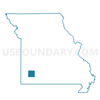
Buck Prairie Voting District, Lawrence County, Missouri
About
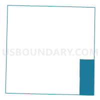
Outline

Summary
| Unique Area Identifier | 608947 |
| Name | Buck Prairie Voting District |
| County | Lawrence County |
| State | Missouri |
| Area (square miles) | 39.99 |
| Land Area (square miles) | 39.92 |
| Water Area (square miles) | 0.07 |
| % of Land Area | 99.83 |
| % of Water Area | 0.17 |
| Latitude of the Internal Point | 36.99674930 |
| Longtitude of the Internal Point | -93.64532850 |
Maps

Graphs
Select a template below for downloading or customizing gragh for Buck Prairie Voting District, Lawrence County, Missouri


Neighbors
Neighoring Voting District (by Name) Neighboring Voting District on the Map
- Aurora North Voting District, Lawrence County, MO
- Aurora Southeast Voting District, Lawrence County, MO
- Crane Creek Voting District, Barry County, MO
- Grant Voting District, Stone County, MO
- Ozark Voting District, Barry County, MO
- POLK Voting District, Christian County, MO
- Turnback Voting District, Lawrence County, MO
Top 10 Neighboring County Subdivision (by Population) Neighboring County Subdivision on the Map
- Aurora township, Lawrence County, MO (9,472)
- Buck Prairie township, Lawrence County, MO (4,067)
- Turnback township, Lawrence County, MO (1,351)
- West Polk township, Christian County, MO (1,045)
- Ozark township, Barry County, MO (955)
- Crane Creek township, Barry County, MO (938)
- Grant township, Stone County, MO (669)
Top 10 Neighboring Place (by Population) Neighboring Place on the Map
Top 10 Neighboring Unified School District (by Population) Neighboring Unified School District on the Map
- Aurora R-8 School District, MO (11,098)
- Marionville R-IX School District, MO (4,616)
- Crane R-III School District, MO (3,558)
- Billings R-IV School District, MO (2,838)
Top 10 Neighboring State Legislative District Lower Chamber (by Population) Neighboring State Legislative District Lower Chamber on the Map
- State House District 141, MO (46,328)
- State House District 132, MO (37,081)
- State House District 68, MO (35,930)
Top 10 Neighboring State Legislative District Upper Chamber (by Population) Neighboring State Legislative District Upper Chamber on the Map
Top 10 Neighboring 111th Congressional District (by Population) Neighboring 111th Congressional District on the Map
Top 10 Neighboring Census Tract (by Population) Neighboring Census Tract on the Map
- Census Tract 901, Stone County, MO (7,480)
- Census Tract 4705, Lawrence County, MO (6,742)
- Census Tract 9601, Barry County, MO (6,127)
- Census Tract 201.01, Christian County, MO (3,045)
- Census Tract 4706.02, Lawrence County, MO (2,892)