


Ferguson School Voting District, Lafayette County, Missouri
About
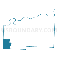
Outline

Summary
| Unique Area Identifier | 608924 |
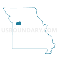
| Name | Ferguson School Voting District |
| County | Lafayette County |
| State | Missouri |
| Area (square miles) | 27.43 |
| Land Area (square miles) | 27.30 |
| Water Area (square miles) | 0.13 |
| % of Land Area | 99.53 |
| % of Water Area | 0.47 |
| Latitude of the Internal Point | 38.95975610 |
| Longtitude of the Internal Point | -94.06792610 |
Maps

Graphs
Select a template below for downloading or customizing gragh for Ferguson School Voting District, Lafayette County, Missouri


Neighbors
Neighoring Voting District (by Name) Neighboring Voting District on the Map
- Bates City Voting District, Lafayette County, MO
- N Odessa Voting District, Lafayette County, MO
- Pittsville Voting District, Johnson County, MO
- S. Odessa I & II Voting District, Lafayette County, MO
- Sni-A-Bar No. 53 & 92 Voting District, Jackson County, MO
- Sni-A-Bar No. 55 Voting District, Jackson County, MO
- Sni-A-Bar No. 57 Voting District, Jackson County, MO
- Sni-A-Bar No. 94,94B,95,& 96 Voting District, Jackson County, MO
- Van Buren No. 34,35,36,& 37 Voting District, Jackson County, MO
- Van Buren No. 38,39,40,40A,40B,40C,40D,40N,& 43 Voting District, Jackson County, MO
Top 10 Neighboring County Subdivision (by Population) Neighboring County Subdivision on the Map
- Sni-A-Bar township, Jackson County, MO (81,927)
- Van Buren township, Jackson County, MO (7,671)
- Sni-A-Bar township, Lafayette County, MO (7,467)
- Clay township, Lafayette County, MO (4,996)
- Jackson township, Johnson County, MO (4,782)
Top 10 Neighboring Place (by Population) Neighboring Place on the Map
Top 10 Neighboring Unified School District (by Population) Neighboring Unified School District on the Map
- Odessa R-VII School District, MO (12,274)
- Oak Grove R-VI School District, MO (10,944)
- Lone Jack C-6 School District, MO (3,100)
Top 10 Neighboring State Legislative District Lower Chamber (by Population) Neighboring State Legislative District Lower Chamber on the Map
- State House District 55, MO (44,553)
- State House District 56, MO (42,172)
- State House District 122, MO (40,384)
Top 10 Neighboring State Legislative District Upper Chamber (by Population) Neighboring State Legislative District Upper Chamber on the Map
- State Senate District 8, MO (205,505)
- State Senate District 31, MO (190,281)
- State Senate District 21, MO (163,305)
Top 10 Neighboring 111th Congressional District (by Population) Neighboring 111th Congressional District on the Map
Top 10 Neighboring Census Tract (by Population) Neighboring Census Tract on the Map
- Census Tract 9601, Johnson County, MO (8,677)
- Census Tract 139.01, Jackson County, MO (6,337)
- Census Tract 906.01, Lafayette County, MO (6,233)
- Census Tract 140.05, Jackson County, MO (5,278)
- Census Tract 906.02, Lafayette County, MO (3,873)
- Census Tract 140.02, Jackson County, MO (1,683)