


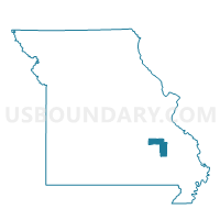
Ironton Voting District, Iron County, Missouri
About
Outline

Summary
| Unique Area Identifier | 608064 |
| Name | Ironton Voting District |
| County | Iron County |
| State | Missouri |
| Area (square miles) | 24.93 |
| Land Area (square miles) | 24.76 |
| Water Area (square miles) | 0.16 |
| % of Land Area | 99.34 |
| % of Water Area | 0.66 |
| Latitude of the Internal Point | 37.60992700 |
| Longtitude of the Internal Point | -90.63152410 |
Maps


Graphs
Select a template below for downloading or customizing gragh for Ironton Voting District, Iron County, Missouri


Neighbors
Neighoring Voting District (by Name) Neighboring Voting District on the Map
- Arcadia Voting District, Iron County, MO
- Doe Run Voting District, St. Francois County, MO
- Ghermanville Voting District, Iron County, MO
- Iron Mountain Voting District, St. Francois County, MO
- Lesterville Voting District, Reynolds County, MO
- Pilot Knob Voting District, Iron County, MO
- St. Francis Voting District, Madison County, MO
Top 10 Neighboring County Subdivision (by Population) Neighboring County Subdivision on the Map
- Arcadia township, Iron County, MO (5,576)
- Pendleton township, St. Francois County, MO (3,372)
- Iron township, St. Francois County, MO (3,257)
- Polk township, Madison County, MO (920)
- Lesterville township, Reynolds County, MO (744)
- Kaolin township, Iron County, MO (523)
Top 10 Neighboring Place (by Population) Neighboring Place on the Map
Top 10 Neighboring Elementary School District (by Population) Neighboring Elementary School District on the Map
Top 10 Neighboring Unified School District (by Population) Neighboring Unified School District on the Map
- Arcadia Valley R-II School District, MO (5,908)
- Bismarck R-V School District, MO (3,674)
- Lesterville R-IV School District, MO (1,295)
Top 10 Neighboring State Legislative District Lower Chamber (by Population) Neighboring State Legislative District Lower Chamber on the Map
- State House District 107, MO (40,428)
- State House District 106, MO (38,873)
- State House District 156, MO (34,716)
- State House District 152, MO (34,200)
Top 10 Neighboring State Legislative District Upper Chamber (by Population) Neighboring State Legislative District Upper Chamber on the Map
Top 10 Neighboring 111th Congressional District (by Population) Neighboring 111th Congressional District on the Map
Top 10 Neighboring Census Tract (by Population) Neighboring Census Tract on the Map
- Census Tract 9507, St. Francois County, MO (8,057)
- Census Tract 9603, Madison County, MO (3,436)
- Census Tract 9506, St. Francois County, MO (3,336)
- Census Tract 3801, Reynolds County, MO (3,058)
- Census Tract 9503, Iron County, MO (2,885)
- Census Tract 9502, Iron County, MO (2,700)