


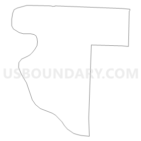
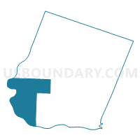
Boonslick Voting District, Howard County, Missouri
About
Outline
Summary
| Unique Area Identifier | 608041 |
| Name | Boonslick Voting District |
| County | Howard County |
| State | Missouri |
| Area (square miles) | 57.17 |
| Land Area (square miles) | 54.91 |
| Water Area (square miles) | 2.26 |
| % of Land Area | 96.05 |
| % of Water Area | 3.95 |
| Latitude of the Internal Point | 39.07126920 |
| Longtitude of the Internal Point | -92.87176980 |
Maps


Graphs
Select a template below for downloading or customizing gragh for Boonslick Voting District, Howard County, Missouri


Neighbors
Neighoring Voting District (by Name) Neighboring Voting District on the Map
- Arrow Rock Voting District, Saline County, MO
- Blackwater Voting District, Cooper County, MO
- Boonville Rural No. 2 Voting District, Cooper County, MO
- Chariton Voting District, Howard County, MO
- Clay Voting District, Saline County, MO
- Franklin Voting District, Howard County, MO
- Richmond Voting District, Howard County, MO
Top 10 Neighboring County Subdivision (by Population) Neighboring County Subdivision on the Map
- Boonville township, Cooper County, MO (10,371)
- Richmond township, Howard County, MO (3,676)
- Franklin township, Howard County, MO (1,798)
- Chariton township, Howard County, MO (1,575)
- Arrow Rock township, Saline County, MO (793)
- Boonslick township, Howard County, MO (521)
- Clay township, Saline County, MO (419)
- Lamine township, Cooper County, MO (268)
Top 10 Neighboring Elementary School District (by Population) Neighboring Elementary School District on the Map
Top 10 Neighboring Unified School District (by Population) Neighboring Unified School District on the Map
- Boonville School District, MO (11,591)
- Fayette R-III School District, MO (5,145)
- New Franklin R-I School District, MO (2,646)
- Howard County R-II School District, MO (2,087)
Top 10 Neighboring State Legislative District Lower Chamber (by Population) Neighboring State Legislative District Lower Chamber on the Map
- State House District 9, MO (36,616)
- State House District 117, MO (35,534)
- State House District 26, MO (33,935)
Top 10 Neighboring State Legislative District Upper Chamber (by Population) Neighboring State Legislative District Upper Chamber on the Map
Top 10 Neighboring 111th Congressional District (by Population) Neighboring 111th Congressional District on the Map
Top 10 Neighboring Census Tract (by Population) Neighboring Census Tract on the Map
- Census Tract 9505, Cooper County, MO (4,895)
- Census Tract 9602, Howard County, MO (3,476)
- Census Tract 9601, Howard County, MO (2,950)
- Census Tract 908, Saline County, MO (2,575)
Top 10 Neighboring 5-Digit ZIP Code Tabulation Area (by Population) Neighboring 5-Digit ZIP Code Tabulation Area on the Map
- 65233, MO (11,703)
- 65248, MO (4,619)
- 65349, MO (2,441)
- 65254, MO (1,810)
- 65347, MO (681)
- 65250, MO (617)
- 65322, MO (587)