


Southeast Voting District, Holt County, Missouri
About
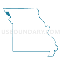
Outline

Summary
| Unique Area Identifier | 608033 |
| Name | Southeast Voting District |
| County | Holt County |
| State | Missouri |
| Area (square miles) | 145.71 |
| Land Area (square miles) | 144.60 |
| Water Area (square miles) | 1.11 |
| % of Land Area | 99.24 |
| % of Water Area | 0.76 |
| Latitude of the Internal Point | 40.00054350 |
| Longtitude of the Internal Point | -95.09453450 |
Maps


Graphs
Select a template below for downloading or customizing gragh for Southeast Voting District, Holt County, Missouri


Neighbors
Neighoring Voting District (by Name) Neighboring Voting District on the Map
- Burr Oak Township Voting District, Doniphan County, KS
- Central Voting District, Holt County, MO
- Clay Voting District, Andrew County, MO
- Fillmore Voting District, Andrew County, MO
- Highland Township Voting District, Doniphan County, KS
- Hughes Voting District, Nodaway County, MO
- Lincoln Voting District, Andrew County, MO
- Northeast Voting District, Holt County, MO
- Southwest Voting District, Holt County, MO
- Troy Township Voting District, Doniphan County, KS
Top 10 Neighboring County Subdivision (by Population) Neighboring County Subdivision on the Map
- Center township, Doniphan County, KS (1,703)
- Iowa township, Doniphan County, KS (1,641)
- Benton township, Holt County, MO (1,493)
- Lincoln township, Andrew County, MO (1,184)
- Lewis township, Holt County, MO (1,051)
- Jackson township, Andrew County, MO (620)
- Clay township, Holt County, MO (522)
- Hughes township, Nodaway County, MO (426)
- Forest township, Holt County, MO (353)
- Clay township, Andrew County, MO (259)
Top 10 Neighboring Place (by Population) Neighboring Place on the Map
Top 10 Neighboring Unified School District (by Population) Neighboring Unified School District on the Map
- Savannah R-III School District, MO (13,635)
- Unified School District 111, KS (2,612)
- Wathena Unified School District 406, KS (2,226)
- Troy Public Schools Unified School District 429, KS (1,908)
- North Andrew County R-VI School District, MO (1,898)
- South Holt County R-I School District, MO (1,865)
- Holt County R-II School District, MO (1,802)
- Nodaway-Holt R-VII School District, MO (1,574)
Top 10 Neighboring State Legislative District Lower Chamber (by Population) Neighboring State Legislative District Lower Chamber on the Map
- State House District 28, MO (38,291)
- State House District 4, MO (35,512)
- State House District 63, KS (22,789)
Top 10 Neighboring State Legislative District Upper Chamber (by Population) Neighboring State Legislative District Upper Chamber on the Map
Top 10 Neighboring 111th Congressional District (by Population) Neighboring 111th Congressional District on the Map
Top 10 Neighboring Census Tract (by Population) Neighboring Census Tract on the Map
- Census Tract 203, Doniphan County, KS (3,449)
- Census Tract 4702, Nodaway County, MO (2,762)
- Census Tract 201, Doniphan County, KS (2,308)
- Census Tract 202, Doniphan County, KS (2,188)
- Census Tract 103, Andrew County, MO (2,063)
- Census Tract 9603, Holt County, MO (1,745)
- Census Tract 9602, Holt County, MO (1,735)
- Census Tract 9601, Holt County, MO (1,432)
Top 10 Neighboring 5-Digit ZIP Code Tabulation Area (by Population) Neighboring 5-Digit ZIP Code Tabulation Area on the Map
- 64485, MO (8,124)
- 66090, KS (2,520)
- 66087, KS (2,042)
- 64470, MO (1,631)
- 64473, MO (1,457)
- 66035, KS (1,311)
- 64421, MO (952)
- 64466, MO (541)
- 64449, MO (451)
- 64451, MO (446)