


Preston Voting District, Hickory County, Missouri
About
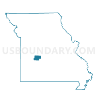
Outline

Summary
| Unique Area Identifier | 608024 |
| Name | Preston Voting District |
| County | Hickory County |
| State | Missouri |
| Area (square miles) | 60.05 |
| Land Area (square miles) | 59.88 |
| Water Area (square miles) | 0.17 |
| % of Land Area | 99.72 |
| % of Water Area | 0.28 |
| Latitude of the Internal Point | 37.94169330 |
| Longtitude of the Internal Point | -93.16154480 |
Maps


Graphs
Select a template below for downloading or customizing gragh for Preston Voting District, Hickory County, Missouri


Neighbors
Neighoring Voting District (by Name) Neighboring Voting District on the Map
- Carson's Corner Voting District, Hickory County, MO
- Cross Timbers-Jordan Voting District, Hickory County, MO
- Lincoln Voting District, Dallas County, MO
- Macks Creek Voting District, Camden County, MO
- Pittsburg Voting District, Hickory County, MO
- Pleasant Ridge Voting District, Hickory County, MO
- Sherman Voting District, Dallas County, MO
Top 10 Neighboring County Subdivision (by Population) Neighboring County Subdivision on the Map
- Russell township, Camden County, MO (4,161)
- Green township, Hickory County, MO (2,384)
- Lincoln township, Dallas County, MO (986)
- Stark township, Hickory County, MO (958)
- Center township, Hickory County, MO (874)
- Cross Timbers township, Hickory County, MO (605)
- Sherman township, Dallas County, MO (536)
- Jordan township, Hickory County, MO (171)
Top 10 Neighboring Place (by Population) Neighboring Place on the Map
Top 10 Neighboring Unified School District (by Population) Neighboring Unified School District on the Map
- Hickory County R-I School District, MO (4,869)
- Hermitage R-IV School District, MO (3,069)
- Macks Creek R-V School District, MO (2,450)
Top 10 Neighboring State Legislative District Lower Chamber (by Population) Neighboring State Legislative District Lower Chamber on the Map
Top 10 Neighboring State Legislative District Upper Chamber (by Population) Neighboring State Legislative District Upper Chamber on the Map
Top 10 Neighboring 111th Congressional District (by Population) Neighboring 111th Congressional District on the Map
Top 10 Neighboring Census Tract (by Population) Neighboring Census Tract on the Map
- Census Tract 9508, Camden County, MO (6,817)
- Census Tract 4801, Dallas County, MO (4,724)
- Census Tract 4705, Hickory County, MO (3,956)
- Census Tract 4701, Hickory County, MO (3,094)
- Census Tract 4703, Hickory County, MO (2,577)