


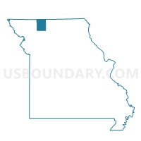
Wesley Voting District, Harrison County, Missouri
About
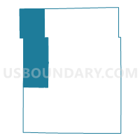
Outline

Summary
| Unique Area Identifier | 607997 |
| Name | Wesley Voting District |
| County | Harrison County |
| State | Missouri |
| Area (square miles) | 114.53 |
| Land Area (square miles) | 113.92 |
| Water Area (square miles) | 0.61 |
| % of Land Area | 99.46 |
| % of Water Area | 0.54 |
| Latitude of the Internal Point | 40.43294560 |
| Longtitude of the Internal Point | -94.16511510 |
Maps

Graphs
Select a template below for downloading or customizing gragh for Wesley Voting District, Harrison County, Missouri


Neighbors
Neighoring Voting District (by Name) Neighboring Voting District on the Map
- Allen Voting District, Worth County, MO
- Athens North Voting District, Gentry County, MO
- Bethany West Voting District, Harrison County, MO
- Eagleville Voting District, Harrison County, MO
- Howard/Lone Star Voting District, Gentry County, MO
- LOTTS CREEK TWP Voting District, Ringgold County, IA
- New Hampton Voting District, Harrison County, MO
- RILEY TWP Voting District, Ringgold County, IA
- Smith Voting District, Worth County, MO
Top 10 Neighboring County Subdivision (by Population) Neighboring County Subdivision on the Map
- Bethany township, Harrison County, MO (3,674)
- Athens township, Gentry County, MO (2,178)
- White Oak township, Harrison County, MO (529)
- Union township, Harrison County, MO (411)
- Jefferson township, Harrison County, MO (328)
- Dallas township, Harrison County, MO (218)
- Allen township, Worth County, MO (165)
- Smith township, Worth County, MO (153)
- Hamilton township, Harrison County, MO (137)
- Washington township, Harrison County, MO (112)
Top 10 Neighboring Unified School District (by Population) Neighboring Unified School District on the Map
- South Harrison School District, MO (5,688)
- Mount Ayr Community School District, IA (4,180)
- Albany R-III School District, MO (2,851)
- Worth County R-III School District, MO (2,216)
- North Harrison R-III School District, MO (1,436)
Top 10 Neighboring State Legislative District Lower Chamber (by Population) Neighboring State Legislative District Lower Chamber on the Map
Top 10 Neighboring State Legislative District Upper Chamber (by Population) Neighboring State Legislative District Upper Chamber on the Map
Top 10 Neighboring 111th Congressional District (by Population) Neighboring 111th Congressional District on the Map
Top 10 Neighboring Census Tract (by Population) Neighboring Census Tract on the Map
- Census Tract 9502, Ringgold County, IA (3,020)
- Census Tract 9601, Gentry County, MO (2,992)
- Census Tract 9502, Harrison County, MO (2,355)
- Census Tract 9601, Worth County, MO (2,171)
Top 10 Neighboring 5-Digit ZIP Code Tabulation Area (by Population) Neighboring 5-Digit ZIP Code Tabulation Area on the Map
- 64424, MO (4,585)
- 50140, IA (2,969)
- 50854, IA (2,303)
- 64456, MO (1,459)
- 64442, MO (882)
- 64471, MO (483)
- 64467, MO (186)
- 64441, MO (178)
- 64458, MO (145)