


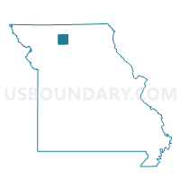
Liberty Voting District, Grundy County, Missouri
About
Outline

Summary
| Unique Area Identifier | 607984 |
| Name | Liberty Voting District |
| County | Grundy County |
| State | Missouri |
| Area (square miles) | 35.19 |
| Land Area (square miles) | 35.03 |
| Water Area (square miles) | 0.16 |
| % of Land Area | 99.55 |
| % of Water Area | 0.45 |
| Latitude of the Internal Point | 40.15686960 |
| Longtitude of the Internal Point | -93.43299840 |
Maps


Graphs
Select a template below for downloading or customizing gragh for Liberty Voting District, Grundy County, Missouri


Neighbors
Neighoring Voting District (by Name) Neighboring Voting District on the Map
- Humphreys Voting District, Sullivan County, MO
- Lincoln Voting District, Grundy County, MO
- Marion Voting District, Grundy County, MO
- Myers Voting District, Grundy County, MO
- Osgood Voting District, Sullivan County, MO
- Taylor Voting District, Sullivan County, MO
- Trenton Ward 3, Grundy County, MO
Top 10 Neighboring County Subdivision (by Population) Neighboring County Subdivision on the Map
- Trenton township, Grundy County, MO (6,393)
- Lincoln township, Grundy County, MO (525)
- Liberty township, Grundy County, MO (436)
- Bowman township, Sullivan County, MO (395)
- Marion township, Grundy County, MO (248)
- Myers township, Grundy County, MO (161)
- Taylor township, Sullivan County, MO (98)