


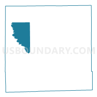
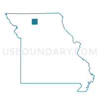
Harrison Voting District, Grundy County, Missouri
About
Outline

Summary
| Unique Area Identifier | 607983 |
| Name | Harrison Voting District |
| County | Grundy County |
| State | Missouri |
| Area (square miles) | 22.01 |
| Land Area (square miles) | 21.61 |
| Water Area (square miles) | 0.40 |
| % of Land Area | 98.17 |
| % of Water Area | 1.83 |
| Latitude of the Internal Point | 40.17678920 |
| Longtitude of the Internal Point | -93.70108720 |
Maps

Graphs
Select a template below for downloading or customizing gragh for Harrison Voting District, Grundy County, Missouri


Neighbors
Neighoring Voting District (by Name) Neighboring Voting District on the Map
- Franklin Voting District, Grundy County, MO
- Lincoln Voting District, Grundy County, MO
- Madison Voting District, Grundy County, MO
- Taylor Voting District, Grundy County, MO
- Trenton Ward 2, Grundy County, MO
- Washington Voting District, Grundy County, MO
Top 10 Neighboring County Subdivision (by Population) Neighboring County Subdivision on the Map
- Trenton township, Grundy County, MO (6,393)
- Madison township, Grundy County, MO (626)
- Lincoln township, Grundy County, MO (525)
- Franklin township, Grundy County, MO (485)
- Taylor township, Grundy County, MO (179)
- Washington township, Grundy County, MO (114)
- Harrison township, Grundy County, MO (108)