


R-1, Dent County, Missouri
About
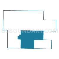
Outline

Summary
| Unique Area Identifier | 607727 |
| Name | R-1 |
| County | Dent County |
| State | Missouri |
| Area (square miles) | 151.99 |
| Land Area (square miles) | 151.89 |
| Water Area (square miles) | 0.10 |
| % of Land Area | 99.94 |
| % of Water Area | 0.06 |
| Latitude of the Internal Point | 37.51498620 |
| Longtitude of the Internal Point | -91.48521230 |
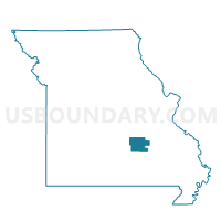
Maps

Graphs
Select a template below for downloading or customizing gragh for R-1, Dent County, Missouri


Neighbors
Neighoring Voting District (by Name) Neighboring Voting District on the Map
- Bunker Voting District, Dent County, MO
- Bunker Voting District, Reynolds County, MO
- Newton Voting District, Shannon County, MO
- R-2, Dent County, MO
- R-4, Dent County, MO
- Spring Creek East Voting District, Dent County, MO
- Spring Creek West Voting District, Dent County, MO
Top 10 Neighboring County Subdivision (by Population) Neighboring County Subdivision on the Map
- Spring Creek East township, Dent County, MO (4,675)
- Spring Creek West township, Dent County, MO (4,157)
- Carroll township, Reynolds County, MO (1,314)
- Franklin township, Dent County, MO (1,028)
- Texas township, Dent County, MO (894)
- Gladden township, Dent County, MO (459)
- Current township, Dent County, MO (447)
- Osage township, Dent County, MO (429)
- Meramec township, Dent County, MO (313)
- Sinkin township, Dent County, MO (298)
Top 10 Neighboring Elementary School District (by Population) Neighboring Elementary School District on the Map
Top 10 Neighboring Unified School District (by Population) Neighboring Unified School District on the Map
- Salem R-80 School District, MO (7,006)
- Summersville R-II School District, MO (3,058)
- Eminence R-I School District, MO (2,029)
- Bunker R-III School District, MO (1,547)
Top 10 Neighboring State Legislative District Lower Chamber (by Population) Neighboring State Legislative District Lower Chamber on the Map
Top 10 Neighboring State Legislative District Upper Chamber (by Population) Neighboring State Legislative District Upper Chamber on the Map
- State Senate District 16, MO (188,295)
- State Senate District 33, MO (184,118)
- State Senate District 3, MO (174,508)
Top 10 Neighboring 111th Congressional District (by Population) Neighboring 111th Congressional District on the Map
Top 10 Neighboring Census Tract (by Population) Neighboring Census Tract on the Map
- Census Tract 9602, Dent County, MO (5,153)
- Census Tract 9601, Dent County, MO (5,024)
- Census Tract 4701, Shannon County, MO (3,393)
- Census Tract 3801, Reynolds County, MO (3,058)