


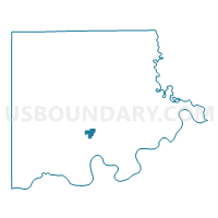
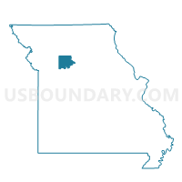
Carrollton Ward 2, Carroll County, Missouri
About
Outline

Summary
| Unique Area Identifier | 607394 |
| Name | Carrollton Ward 2 |
| County | Carroll County |
| State | Missouri |
| Area (square miles) | 1.57 |
| Land Area (square miles) | 1.57 |
| Water Area (square miles) | 0.00 |
| % of Land Area | 100.00 |
| % of Water Area | 0.00 |
| Latitude of the Internal Point | 39.35134390 |
| Longtitude of the Internal Point | -93.49607780 |
Maps

Graphs
Select a template below for downloading or customizing gragh for Carrollton Ward 2, Carroll County, Missouri


Neighbors
Neighoring Voting District (by Name) Neighboring Voting District on the Map
- Carrollton Ward 1, Carroll County, MO
- Carrollton Ward 3, Carroll County, MO
- Trotter/Moss Creek/Wakenda/Sugartree Voting District, Carroll County, MO