


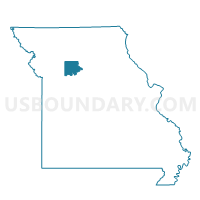
Washington Voting District, Carroll County, Missouri
About
Outline

Summary
| Unique Area Identifier | 607384 |
| Name | Washington Voting District |
| County | Carroll County |
| State | Missouri |
| Area (square miles) | 36.14 |
| Land Area (square miles) | 36.14 |
| Water Area (square miles) | 0.00 |
| % of Land Area | 100.00 |
| % of Water Area | 0.00 |
| Latitude of the Internal Point | 39.56481680 |
| Longtitude of the Internal Point | -93.71324850 |
Maps


Graphs
Select a template below for downloading or customizing gragh for Washington Voting District, Carroll County, Missouri


Neighbors
Neighoring Voting District (by Name) Neighboring Voting District on the Map
- Blue Mound Voting District, Livingston County, MO
- Davis/Fairview Voting District, Caldwell County, MO
- Leslie/Van Horn Voting District, Carroll County, MO
- Monroe Voting District, Livingston County, MO
- Prairie/Fairfield Voting District, Carroll County, MO
- Stet Voting District, Ray County, MO
- Stokes Mound/Hill Voting District, Carroll County, MO
Top 10 Neighboring County Subdivision (by Population) Neighboring County Subdivision on the Map
- Davis township, Caldwell County, MO (1,219)
- Grape Grove township, Ray County, MO (885)
- Blue Mound township, Livingston County, MO (533)
- Monroe township, Livingston County, MO (309)
- Hill township, Carroll County, MO (235)
- Washington township, Carroll County, MO (170)
- Fairview township, Caldwell County, MO (159)
- Fairfield township, Carroll County, MO (155)
- Leslie township, Carroll County, MO (143)
Top 10 Neighboring Unified School District (by Population) Neighboring Unified School District on the Map
- Carrollton R-VII School District, MO (5,621)
- Braymer C-4 School District, MO (1,731)
- Southwest Livingston County R-I School District, MO (1,211)
- Norborne R-VIII School District, MO (1,089)
- Tina-Avalon R-II School District, MO (917)
Top 10 Neighboring State Legislative District Lower Chamber (by Population) Neighboring State Legislative District Lower Chamber on the Map
Top 10 Neighboring State Legislative District Upper Chamber (by Population) Neighboring State Legislative District Upper Chamber on the Map
Top 10 Neighboring 111th Congressional District (by Population) Neighboring 111th Congressional District on the Map
Top 10 Neighboring Census Tract (by Population) Neighboring Census Tract on the Map
- Census Tract 801, Ray County, MO (3,450)
- Census Tract 4802, Livingston County, MO (3,193)
- Census Tract 9501, Caldwell County, MO (2,939)
- Census Tract 9602, Carroll County, MO (2,645)