


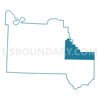
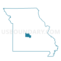
Freedom Voting District, Camden County, Missouri
About
Outline

Summary
| Unique Area Identifier | 607331 |
| Name | Freedom Voting District |
| County | Camden County |
| State | Missouri |
| Area (square miles) | 56.73 |
| Land Area (square miles) | 55.53 |
| Water Area (square miles) | 1.20 |
| % of Land Area | 97.88 |
| % of Water Area | 2.12 |
| Latitude of the Internal Point | 38.01777490 |
| Longtitude of the Internal Point | -92.54389390 |
Maps

Graphs
Select a template below for downloading or customizing gragh for Freedom Voting District, Camden County, Missouri


Neighbors
Neighoring Voting District (by Name) Neighboring Voting District on the Map
- Brumley Voting District, Miller County, MO
- Camdenton 1 Voting District, Camden County, MO
- Crocker Voting District, Pulaski County, MO
- Decaturville Voting District, Camden County, MO
- Hillhouse Voting District, Camden County, MO
- Keethtown Voting District, Miller County, MO
- Montreal Voting District, Camden County, MO
- Osage Beach 3 Voting District, Camden County, MO
Top 10 Neighboring County Subdivision (by Population) Neighboring County Subdivision on the Map
- Pawhuska township, Camden County, MO (7,785)
- Glaze township, Miller County, MO (6,804)
- Kiheka township, Camden County, MO (5,056)
- Tavern township, Pulaski County, MO (3,349)
- Richwoods township, Miller County, MO (3,243)
- Warren township, Camden County, MO (2,922)
- Auglaize township, Camden County, MO (2,444)
- Jackson township, Camden County, MO (860)
Top 10 Neighboring Unified School District (by Population) Neighboring Unified School District on the Map
- Camdenton R-III School District, MO (31,430)
- School of The Osage R-II School District, MO (12,804)
- Iberia R-V School District, MO (3,972)
- Pulaski County R-IV School District, MO (3,431)
- Crocker School District, MO (3,333)
- Camden County R-II School District, MO (2,872)
Top 10 Neighboring State Legislative District Lower Chamber (by Population) Neighboring State Legislative District Lower Chamber on the Map
- State House District 148, MO (42,602)
- State House District 155, MO (41,624)
- State House District 146, MO (37,063)
- State House District 115, MO (37,008)
Top 10 Neighboring State Legislative District Upper Chamber (by Population) Neighboring State Legislative District Upper Chamber on the Map
- State Senate District 16, MO (188,295)
- State Senate District 33, MO (184,118)
- State Senate District 6, MO (181,242)
Top 10 Neighboring 111th Congressional District (by Population) Neighboring 111th Congressional District on the Map
Top 10 Neighboring Census Tract (by Population) Neighboring Census Tract on the Map
- Census Tract 9628, Miller County, MO (6,002)
- Census Tract 9506, Camden County, MO (4,179)
- Census Tract 4701.02, Pulaski County, MO (3,489)
- Census Tract 9509, Camden County, MO (3,242)
Top 10 Neighboring 5-Digit ZIP Code Tabulation Area (by Population) Neighboring 5-Digit ZIP Code Tabulation Area on the Map
- 65556, MO (5,869)
- 65052, MO (3,446)
- 65486, MO (3,423)
- 65452, MO (3,315)
- 65017, MO (1,549)
- 65591, MO (1,512)
- 65567, MO (1,253)