


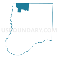
Hatton Voting District, Callaway County, Missouri
About
Outline

Summary
| Unique Area Identifier | 607295 |
| Name | Hatton Voting District |
| County | Callaway County |
| State | Missouri |
| Area (square miles) | 38.31 |
| Land Area (square miles) | 38.05 |
| Water Area (square miles) | 0.26 |
| % of Land Area | 99.32 |
| % of Water Area | 0.68 |
| Latitude of the Internal Point | 39.03310180 |
| Longtitude of the Internal Point | -91.99967920 |
Maps


Graphs
Select a template below for downloading or customizing gragh for Hatton Voting District, Callaway County, Missouri


Neighbors
Neighoring Voting District (by Name) Neighboring Voting District on the Map
- Auxvasse Voting District, Callaway County, MO
- McCredie Voting District, Callaway County, MO
- Millersburg Voting District, Callaway County, MO
- Stephens Voting District, Callaway County, MO
- Wilson/Salt River Voting District, Audrain County, MO
Top 10 Neighboring County Subdivision (by Population) Neighboring County Subdivision on the Map
- Salt River township, Audrain County, MO (9,497)
- Jackson township, Callaway County, MO (2,150)
- Bourbon township, Callaway County, MO (2,059)
- Wilson township, Audrain County, MO (1,633)
- Liberty township, Callaway County, MO (840)
- McCredie township, Callaway County, MO (760)
- Cleveland township, Callaway County, MO (742)
Top 10 Neighboring Unified School District (by Population) Neighboring Unified School District on the Map
- Mexico 59 School District, MO (15,366)
- Centralia R-VI School District, MO (7,249)
- North Callaway R-I School District, MO (6,857)
Top 10 Neighboring State Legislative District Lower Chamber (by Population) Neighboring State Legislative District Lower Chamber on the Map
Top 10 Neighboring State Legislative District Upper Chamber (by Population) Neighboring State Legislative District Upper Chamber on the Map
Top 10 Neighboring 111th Congressional District (by Population) Neighboring 111th Congressional District on the Map
Top 10 Neighboring Census Tract (by Population) Neighboring Census Tract on the Map
- Census Tract 701, Callaway County, MO (5,108)
- Census Tract 9502, Audrain County, MO (4,917)
- Census Tract 9503, Audrain County, MO (3,609)
Top 10 Neighboring 5-Digit ZIP Code Tabulation Area (by Population) Neighboring 5-Digit ZIP Code Tabulation Area on the Map
- 65202, MO (46,547)
- 65265, MO (15,409)
- 65240, MO (7,590)
- 65231, MO (3,334)
- 65262, MO (955)
- 65285, MO (695)