


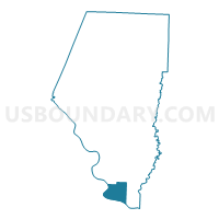
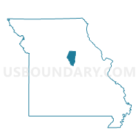
Voting District 32, Boone County, Missouri
About
Outline

Summary
| Unique Area Identifier | 607174 |
| Name | Voting District 32 |
| County | Boone County |
| State | Missouri |
| Area (square miles) | 14.98 |
| Land Area (square miles) | 14.21 |
| Water Area (square miles) | 0.78 |
| % of Land Area | 94.81 |
| % of Water Area | 5.19 |
| Latitude of the Internal Point | 38.69459310 |
| Longtitude of the Internal Point | -92.31113630 |
Maps

Graphs
Select a template below for downloading or customizing gragh for Voting District 32, Boone County, Missouri


Neighbors
Neighoring Voting District (by Name) Neighboring Voting District on the Map
- Voting District 31, Boone County, MO
- Centertown Voting District, Cole County, MO
- Scott Station Voting District, Cole County, MO
- St. Martins Voting District, Cole County, MO
Top 10 Neighboring County Subdivision (by Population) Neighboring County Subdivision on the Map
- Jefferson township, Cole County, MO (54,165)
- Cedar township, Boone County, MO (4,190)
- Marion township, Cole County, MO (3,823)
Top 10 Neighboring Place (by Population) Neighboring Place on the Map
Top 10 Neighboring Unified School District (by Population) Neighboring Unified School District on the Map
- Jefferson City Public Schools, MO (71,991)
- Southern Boone County R-I School District, MO (7,932)
- Moniteau County C-1 School District, MO (1,409)