


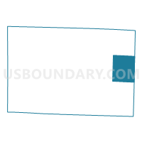
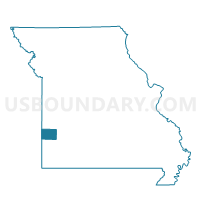
Newport Voting District, Barton County, Missouri
About
Outline

Summary
| Unique Area Identifier | 607080 |
| Name | Newport Voting District |
| County | Barton County |
| State | Missouri |
| Area (square miles) | 30.48 |
| Land Area (square miles) | 30.22 |
| Water Area (square miles) | 0.26 |
| % of Land Area | 99.16 |
| % of Water Area | 0.84 |
| Latitude of the Internal Point | 37.51275870 |
| Longtitude of the Internal Point | -94.12193830 |
Maps

Graphs
Select a template below for downloading or customizing gragh for Newport Voting District, Barton County, Missouri


Neighbors
Neighoring Voting District (by Name) Neighboring Voting District on the Map
- Cedar & Ernest Voting District, Dade County, MO
- Doyles Port Voting District, Barton County, MO
- Golden City Voting District, Barton County, MO
- Lamar Voting District, Barton County, MO
- Milford Voting District, Barton County, MO
- West Lockwood/W. Ward City/Marion Voting District, Dade County, MO
Top 10 Neighboring County Subdivision (by Population) Neighboring County Subdivision on the Map
- Lamar township, Barton County, MO (1,490)
- Golden City township, Barton County, MO (1,097)
- Newport township, Barton County, MO (337)
- Cedar township, Dade County, MO (304)
- Milford township, Barton County, MO (272)
- Marion township, Dade County, MO (232)
- Doylesport township, Barton County, MO (231)
Top 10 Neighboring Unified School District (by Population) Neighboring Unified School District on the Map
- Lamar R-I School District, MO (7,415)
- Lockwood R-I School District, MO (2,303)
- Golden City School District, MO (1,688)