


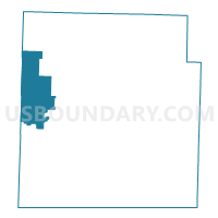
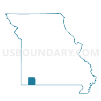
Wheaton Voting District, Barry County, Missouri
About
Outline

Summary
| Unique Area Identifier | 607054 |
| Name | Wheaton Voting District |
| County | Barry County |
| State | Missouri |
| Area (square miles) | 42.12 |
| Land Area (square miles) | 41.98 |
| Water Area (square miles) | 0.14 |
| % of Land Area | 99.66 |
| % of Water Area | 0.34 |
| Latitude of the Internal Point | 36.75468710 |
| Longtitude of the Internal Point | -94.03454140 |
Maps

Graphs
Select a template below for downloading or customizing gragh for Wheaton Voting District, Barry County, Missouri


Neighbors
Neighoring Voting District (by Name) Neighboring Voting District on the Map
- Butterfield Voting District, Barry County, MO
- Capps Creek Voting District, Barry County, MO
- Exeter Voting District, Barry County, MO
- Fairview Voting District, Newton County, MO
- Purdy Voting District, Barry County, MO
- Richwood Voting District, McDonald County, MO
Top 10 Neighboring County Subdivision (by Population) Neighboring County Subdivision on the Map
- Franklin township, Newton County, MO (1,795)
- Liberty township, Barry County, MO (1,165)
- Wheaton township, Barry County, MO (1,133)
- Richwood township, McDonald County, MO (638)
- Capps Creek township, Barry County, MO (630)
- Corsicana township, Barry County, MO (418)
- Pioneer township, Barry County, MO (193)
Top 10 Neighboring Place (by Population) Neighboring Place on the Map
Top 10 Neighboring Unified School District (by Population) Neighboring Unified School District on the Map
- McDonald County R-I School District, MO (18,808)
- East Newton County R-VI School District, MO (8,895)
- Pierce City R-VI School District, MO (4,344)
- Purdy R-II School District, MO (3,365)
- Wheaton R-III School District, MO (2,375)
- Exeter R-VI School District, MO (1,891)
Top 10 Neighboring State Legislative District Lower Chamber (by Population) Neighboring State Legislative District Lower Chamber on the Map
Top 10 Neighboring State Legislative District Upper Chamber (by Population) Neighboring State Legislative District Upper Chamber on the Map
Top 10 Neighboring 111th Congressional District (by Population) Neighboring 111th Congressional District on the Map
Top 10 Neighboring Census Tract (by Population) Neighboring Census Tract on the Map
- Census Tract 9602, Barry County, MO (6,418)
- Census Tract 701, McDonald County, MO (6,194)
- Census Tract 9604.02, Barry County, MO (3,641)
- Census Tract 210, Newton County, MO (3,379)
Top 10 Neighboring 5-Digit ZIP Code Tabulation Area (by Population) Neighboring 5-Digit ZIP Code Tabulation Area on the Map
- 65708, MO (12,624)
- 65625, MO (8,328)
- 65723, MO (3,606)
- 65734, MO (3,497)
- 65647, MO (2,347)
- 64866, MO (1,484)
- 64861, MO (1,179)
- 64842, MO (829)
- 64874, MO (760)