


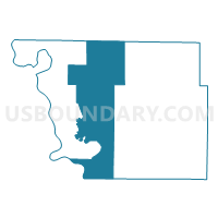
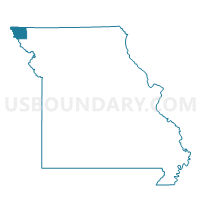
Rock Port Voting District, Atchison County, Missouri
About
Outline

Summary
| Unique Area Identifier | 607029 |
| Name | Rock Port Voting District |
| County | Atchison County |
| State | Missouri |
| Area (square miles) | 124.83 |
| Land Area (square miles) | 124.50 |
| Water Area (square miles) | 0.33 |
| % of Land Area | 99.74 |
| % of Water Area | 0.26 |
| Latitude of the Internal Point | 40.44699650 |
| Longtitude of the Internal Point | -95.51138630 |
Maps

Graphs
Select a template below for downloading or customizing gragh for Rock Port Voting District, Atchison County, Missouri


Neighbors
Neighoring Voting District (by Name) Neighboring Voting District on the Map
- Fairfax Voting District, Atchison County, MO
- LOCUST GROVE TWP Voting District, Fremont County, IA
- MADISON TWP Voting District, Fremont County, IA
- Nemaha Precinct, Nemaha County, NE
- Northwest Voting District, Holt County, MO
- Phelps City Voting District, Atchison County, MO
- Tarkio Voting District, Atchison County, MO
- Watson Voting District, Atchison County, MO
- Westboro Voting District, Atchison County, MO
Top 10 Neighboring County Subdivision (by Population) Neighboring County Subdivision on the Map
- Clay township, Atchison County, MO (1,798)
- Tarkio township, Atchison County, MO (1,752)
- Clark township, Atchison County, MO (895)
- Lincoln township, Atchison County, MO (378)
- Nemaha precinct, Nemaha County, NE (303)
- Polk township, Atchison County, MO (226)
- Locust Grove township, Fremont County, IA (164)
- Nishnabotna township, Atchison County, MO (155)
- Madison township, Fremont County, IA (141)
- Buchanan township, Atchison County, MO (83)
Top 10 Neighboring Place (by Population) Neighboring Place on the Map
Top 10 Neighboring Unified School District (by Population) Neighboring Unified School District on the Map
- Falls City Public Schools, NE (6,044)
- Humboldt Table Rock Steinauer Public Schools, NE (3,300)
- Rock Port R-II School District, MO (2,329)
- Tarkio R-I School District, MO (2,264)
- Hamburg Community School District, IA (1,671)
- Farragut Community School District, IA (1,445)
- Fairfax R-III School District, MO (1,092)
- Craig R-III School District, MO (730)
Top 10 Neighboring State Legislative District Lower Chamber (by Population) Neighboring State Legislative District Lower Chamber on the Map
Top 10 Neighboring State Legislative District Upper Chamber (by Population) Neighboring State Legislative District Upper Chamber on the Map
- State Senate District 12, MO (169,332)
- State Senate District 49, IA (60,560)
- State Senate District 1, NE (33,429)
Top 10 Neighboring 111th Congressional District (by Population) Neighboring 111th Congressional District on the Map
- Congressional District 6, MO (693,974)
- Congressional District 1, NE (626,092)
- Congressional District 5, IA (577,453)
Top 10 Neighboring Census Tract (by Population) Neighboring Census Tract on the Map
- Census Tract 9681, Nemaha County, NE (3,595)
- Census Tract 9501, Atchison County, MO (3,215)
- Census Tract 9502, Atchison County, MO (2,470)
- Census Tract 9701, Fremont County, IA (2,085)
- Census Tract 9601, Holt County, MO (1,432)
Top 10 Neighboring 5-Digit ZIP Code Tabulation Area (by Population) Neighboring 5-Digit ZIP Code Tabulation Area on the Map
- 64482, MO (2,101)
- 64491, MO (1,875)
- 51640, IA (1,748)
- 64446, MO (1,117)
- 64437, MO (792)
- 64498, MO (375)
- 68414, NE (256)
- 64496, MO (154)