


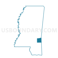
Chaparral Voting District, Wayne County, Mississippi
About
Outline

Summary
| Unique Area Identifier | 606901 |
| Name | Chaparral Voting District |
| County | Wayne County |
| State | Mississippi |
| Area (square miles) | 18.26 |
| Land Area (square miles) | 18.26 |
| Water Area (square miles) | 0.01 |
| % of Land Area | 99.97 |
| % of Water Area | 0.03 |
| Latitude of the Internal Point | 31.81937440 |
| Longtitude of the Internal Point | -88.61587130 |
Maps


Graphs
Select a template below for downloading or customizing gragh for Chaparral Voting District, Wayne County, Mississippi


Neighbors
Neighoring Voting District (by Name) Neighboring Voting District on the Map
- Diamond Voting District, Wayne County, MS
- Hiwannee Voting District, Wayne County, MS
- Langsdale Voting District, Clarke County, MS
- Matherville Voting District, Wayne County, MS
Top 10 Neighboring County Subdivision (by Population) Neighboring County Subdivision on the Map
- District 2, Wayne County, MS (4,997)
- District 3, Wayne County, MS (3,744)
- District 5, Clarke County, MS (2,517)