


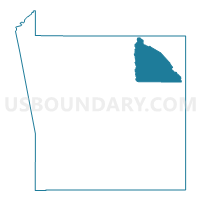
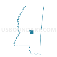
Steele Voting District, Scott County, Mississippi
About
Outline

Summary
| Unique Area Identifier | 606612 |
| Name | Steele Voting District |
| County | Scott County |
| State | Mississippi |
| Area (square miles) | 30.82 |
| Land Area (square miles) | 30.60 |
| Water Area (square miles) | 0.21 |
| % of Land Area | 99.30 |
| % of Water Area | 0.70 |
| Latitude of the Internal Point | 32.51166320 |
| Longtitude of the Internal Point | -89.41146090 |
Maps

Graphs
Select a template below for downloading or customizing gragh for Steele Voting District, Scott County, Mississippi


Neighbors
Neighoring Voting District (by Name) Neighboring Voting District on the Map
- Harperville Voting District, Scott County, MS
- Hillsboro Voting District, Scott County, MS
- Langs Mill Voting District, Scott County, MS
- Salem Voting District, Scott County, MS
- Sebastapol Voting District, Scott County, MS
Top 10 Neighboring County Subdivision (by Population) Neighboring County Subdivision on the Map
Top 10 Neighboring Unified School District (by Population) Neighboring Unified School District on the Map
Top 10 Neighboring State Legislative District Lower Chamber (by Population) Neighboring State Legislative District Lower Chamber on the Map
- State House District 45, MS (25,090)
- State House District 78, MS (22,341)
- State House District 75, MS (22,303)