


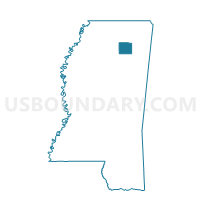
Longview Voting District, Pontotoc County, Mississippi
About
Outline

Summary
| Unique Area Identifier | 606504 |
| Name | Longview Voting District |
| County | Pontotoc County |
| State | Mississippi |
| Area (square miles) | 8.19 |
| Land Area (square miles) | 7.96 |
| Water Area (square miles) | 0.23 |
| % of Land Area | 97.18 |
| % of Water Area | 2.82 |
| Latitude of the Internal Point | 34.27015420 |
| Longtitude of the Internal Point | -88.88272240 |
Maps


Graphs
Select a template below for downloading or customizing gragh for Longview Voting District, Pontotoc County, Mississippi


Neighbors
Neighoring Voting District (by Name) Neighboring Voting District on the Map
- Bankhead Voting District, Pontotoc County, MS
- Bethel Voting District, Pontotoc County, MS
- Hoyle Voting District, Pontotoc County, MS