


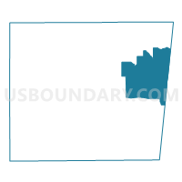
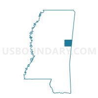
Prairie Point Voting District, Noxubee County, Mississippi
About
Outline

Summary
| Unique Area Identifier | 606353 |
| Name | Prairie Point Voting District |
| County | Noxubee County |
| State | Mississippi |
| Area (square miles) | 61.70 |
| Land Area (square miles) | 61.65 |
| Water Area (square miles) | 0.05 |
| % of Land Area | 99.92 |
| % of Water Area | 0.08 |
| Latitude of the Internal Point | 33.14809930 |
| Longtitude of the Internal Point | -88.38299240 |
Maps

Graphs
Select a template below for downloading or customizing gragh for Prairie Point Voting District, Noxubee County, Mississippi


Neighbors
Neighoring Voting District (by Name) Neighboring Voting District on the Map
- Cliftonville Voting District, Noxubee County, MS
- Cochrane-Dancy, Pickens County, AL
- Noxubee Cnty Vo-Tech Cen. Voting District, Noxubee County, MS
- Savannah Voting District, Noxubee County, MS
Top 10 Neighboring County Subdivision (by Population) Neighboring County Subdivision on the Map
- Aliceville CCD, Pickens County, AL (5,384)
- District 1, Noxubee County, MS (2,382)
- District 2, Noxubee County, MS (2,283)
Top 10 Neighboring Unified School District (by Population) Neighboring Unified School District on the Map
Top 10 Neighboring State Legislative District Lower Chamber (by Population) Neighboring State Legislative District Lower Chamber on the Map
Top 10 Neighboring State Legislative District Upper Chamber (by Population) Neighboring State Legislative District Upper Chamber on the Map
- State Senate District 21, AL (140,682)
- State Senate District 32, MS (49,900)
- State Senate District 16, MS (49,681)