


Leaf Voting District, Greene County, Mississippi
About
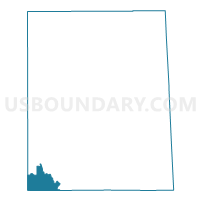
Outline

Summary
| Unique Area Identifier | 605415 |
| Name | Leaf Voting District |
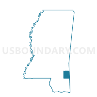
| County | Greene County |
| State | Mississippi |
| Area (square miles) | 14.00 |
| Land Area (square miles) | 13.99 |
| Water Area (square miles) | 0.01 |
| % of Land Area | 99.92 |
| % of Water Area | 0.08 |
| Latitude of the Internal Point | 31.02099160 |
| Longtitude of the Internal Point | -88.80074470 |
Maps

Graphs
Select a template below for downloading or customizing gragh for Leaf Voting District, Greene County, Mississippi


Neighbors
Neighoring Voting District (by Name) Neighboring Voting District on the Map
- Deep Creek Voting District, Perry County, MS
- McLain Voting District, Greene County, MS
- Salem School Voting District, George County, MS
- Thompson Hill Voting District, Perry County, MS
- Vernal Voting District, Greene County, MS
Top 10 Neighboring County Subdivision (by Population) Neighboring County Subdivision on the Map
- District 4, George County, MS (4,544)
- District 5, Perry County, MS (2,443)
- District 4, Greene County, MS (2,431)
- District 5, Greene County, MS (2,199)
Top 10 Neighboring Unified School District (by Population) Neighboring Unified School District on the Map
- George County School District, MS (22,578)
- Greene County School District, MS (14,400)
- Perry County Schools, MS (8,511)
Top 10 Neighboring State Legislative District Lower Chamber (by Population) Neighboring State Legislative District Lower Chamber on the Map
Top 10 Neighboring State Legislative District Upper Chamber (by Population) Neighboring State Legislative District Upper Chamber on the Map
Top 10 Neighboring 111th Congressional District (by Population) Neighboring 111th Congressional District on the Map
Top 10 Neighboring Census Tract (by Population) Neighboring Census Tract on the Map
- Census Tract 9502, Greene County, MS (6,308)
- Census Tract 9502, Perry County, MS (3,672)
- Census Tract 9503.02, George County, MS (2,997)