


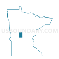
Staples Voting District, Todd County, Minnesota
About
Outline

Summary
| Unique Area Identifier | 604656 |
| Name | Staples Voting District |
| County | Todd County |
| State | Minnesota |
| Area (square miles) | 2.19 |
| Land Area (square miles) | 2.19 |
| Water Area (square miles) | 0.00 |
| % of Land Area | 99.77 |
| % of Water Area | 0.23 |
| Latitude of the Internal Point | 46.35985310 |
| Longtitude of the Internal Point | -94.80147560 |
Maps

Graphs
Select a template below for downloading or customizing gragh for Staples Voting District, Todd County, Minnesota


Neighbors
Neighoring Voting District (by Name) Neighboring Voting District on the Map
- Staples Voting District, Wadena County, MN
- Staples Twp. Voting District, Todd County, MN
- Villard Twp. Voting District, Todd County, MN
Top 10 Neighboring County Subdivision (by Population) Neighboring County Subdivision on the Map
- Staples city, Todd County, MN (2,110)
- Staples city, Wadena County, MN (871)
- Villard township, Todd County, MN (656)
- Staples township, Todd County, MN (627)