


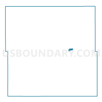
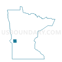
Morris W-2 P-B, Stevens County, Minnesota
About
Outline

Summary
| Unique Area Identifier | 604584 |
| Name | Morris W-2 P-B |
| County | Stevens County |
| State | Minnesota |
| Area (square miles) | 0.39 |
| Land Area (square miles) | 0.39 |
| Water Area (square miles) | 0.00 |
| % of Land Area | 100.00 |
| % of Water Area | 0.00 |
| Latitude of the Internal Point | 45.59246160 |
| Longtitude of the Internal Point | -95.89468100 |
Maps

Graphs
Select a template below for downloading or customizing gragh for Morris W-2 P-B, Stevens County, Minnesota


Neighbors
Neighoring Voting District (by Name) Neighboring Voting District on the Map
- Framnas Twp. Voting District, Stevens County, MN
- Morris Twp. Voting District, Stevens County, MN
- Morris W-1 P-B, Stevens County, MN
- Morris W-2 P-A, Stevens County, MN
- Morris W-3 P-A, Stevens County, MN
Top 10 Neighboring County Subdivision (by Population) Neighboring County Subdivision on the Map
- Morris city, Stevens County, MN (5,286)
- Morris township, Stevens County, MN (396)
- Framnas township, Stevens County, MN (305)