


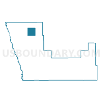
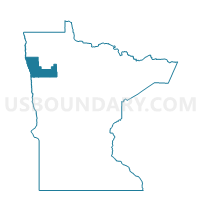
Angus Twp. Voting District, Polk County, Minnesota
About
Outline

Summary
| Unique Area Identifier | 603669 |
| Name | Angus Twp. Voting District |
| County | Polk County |
| State | Minnesota |
| Area (square miles) | 36.07 |
| Land Area (square miles) | 36.07 |
| Water Area (square miles) | 0.00 |
| % of Land Area | 100.00 |
| % of Water Area | 0.00 |
| Latitude of the Internal Point | 48.06477680 |
| Longtitude of the Internal Point | -96.69524160 |
Maps

Graphs
Select a template below for downloading or customizing gragh for Angus Twp. Voting District, Polk County, Minnesota


Neighbors
Neighoring Voting District (by Name) Neighboring Voting District on the Map
- Brandt Twp. Voting District, Polk County, MN
- Brislet Twp. Voting District, Polk County, MN
- Euclid Twp. Voting District, Polk County, MN
- Farley Twp. Voting District, Polk County, MN
- Helgeland Twp. Voting District, Polk County, MN
- Keystone Twp. Voting District, Polk County, MN
- Tabor Twp. Voting District, Polk County, MN
Top 10 Neighboring County Subdivision (by Population) Neighboring County Subdivision on the Map
- Euclid township, Polk County, MN (151)
- Tabor township, Polk County, MN (113)
- Keystone township, Polk County, MN (91)
- Angus township, Polk County, MN (76)
- Helgeland township, Polk County, MN (54)
- Brislet township, Polk County, MN (53)
- Brandt township, Polk County, MN (50)
- Farley township, Polk County, MN (45)
Top 10 Neighboring Unified School District (by Population) Neighboring Unified School District on the Map
- East Grand Forks Public School District, MN (10,085)
- Crookston Public School District, MN (9,712)
- Warren-Alvarado-Oslo School District, MN (3,651)