


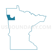
Crookston W-5, Polk County, Minnesota
About
Outline

Summary
| Unique Area Identifier | 603664 |
| Name | Crookston W-5 |
| County | Polk County |
| State | Minnesota |
| Area (square miles) | 1.14 |
| Land Area (square miles) | 1.14 |
| Water Area (square miles) | 0.00 |
| % of Land Area | 100.00 |
| % of Water Area | 0.00 |
| Latitude of the Internal Point | 47.76304790 |
| Longtitude of the Internal Point | -96.60519380 |
Maps


Graphs
Select a template below for downloading or customizing gragh for Crookston W-5, Polk County, Minnesota


Neighbors
Neighoring Voting District (by Name) Neighboring Voting District on the Map
- Andover Twp. Voting District, Polk County, MN
- Crookston Twp. Voting District, Polk County, MN
- Crookston W-1, Polk County, MN
- Crookston W-4, Polk County, MN
- Fairfax Twp. Voting District, Polk County, MN
Top 10 Neighboring County Subdivision (by Population) Neighboring County Subdivision on the Map
- Crookston city, Polk County, MN (7,891)
- Crookston township, Polk County, MN (413)
- Fairfax township, Polk County, MN (198)
- Andover township, Polk County, MN (119)