


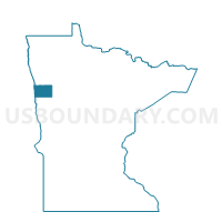
Strand Twp. Voting District, Norman County, Minnesota
About
Outline

Summary
| Unique Area Identifier | 603376 |
| Name | Strand Twp. Voting District |
| County | Norman County |
| State | Minnesota |
| Area (square miles) | 35.89 |
| Land Area (square miles) | 35.85 |
| Water Area (square miles) | 0.03 |
| % of Land Area | 99.90 |
| % of Water Area | 0.10 |
| Latitude of the Internal Point | 47.36180810 |
| Longtitude of the Internal Point | -96.25319020 |
Maps


Graphs
Select a template below for downloading or customizing gragh for Strand Twp. Voting District, Norman County, Minnesota


Neighbors
Neighoring Voting District (by Name) Neighboring Voting District on the Map
- Bear Park Twp. Voting District, Norman County, MN
- Fossum Twp. Voting District, Norman County, MN
- Gary Voting District, Norman County, MN
- Green Meadow Twp. Voting District, Norman County, MN
- Lake Ida Twp. Voting District, Norman County, MN
- Spring Creek Twp. Voting District, Norman County, MN
- Sundal Twp. Voting District, Norman County, MN
- Waukon Twp. Voting District, Norman County, MN
- Wild Rice Twp. Voting District, Norman County, MN
Top 10 Neighboring County Subdivision (by Population) Neighboring County Subdivision on the Map
- Wild Rice township, Norman County, MN (256)
- Gary city, Norman County, MN (214)
- Bear Park township, Norman County, MN (192)
- Lake Ida township, Norman County, MN (160)
- Sundal township, Norman County, MN (157)
- Fossum township, Norman County, MN (156)
- Waukon township, Norman County, MN (114)
- Green Meadow township, Norman County, MN (108)
- Strand township, Norman County, MN (99)
- Spring Creek township, Norman County, MN (81)