


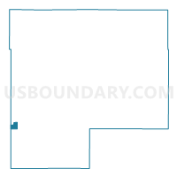
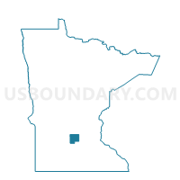
Stewart Voting District, McLeod County, Minnesota
About
Outline

Summary
| Unique Area Identifier | 602983 |
| Name | Stewart Voting District |
| County | McLeod County |
| State | Minnesota |
| Area (square miles) | 0.81 |
| Land Area (square miles) | 0.80 |
| Water Area (square miles) | 0.00 |
| % of Land Area | 99.65 |
| % of Water Area | 0.35 |
| Latitude of the Internal Point | 44.72377210 |
| Longtitude of the Internal Point | -94.48659460 |
Maps

Graphs
Select a template below for downloading or customizing gragh for Stewart Voting District, McLeod County, Minnesota


Neighbors
Neighoring Voting District (by Name) Neighboring Voting District on the Map
- Collins Twp. Voting District, McLeod County, MN
- Grafton Twp. Voting District, Sibley County, MN
- Preston Lake Twp. Voting District, Renville County, MN
- Round Grove Twp. Voting District, McLeod County, MN
Top 10 Neighboring County Subdivision (by Population) Neighboring County Subdivision on the Map
- Stewart city, McLeod County, MN (571)
- Collins township, McLeod County, MN (473)
- Preston Lake township, Renville County, MN (271)
- Round Grove township, McLeod County, MN (251)
- Grafton township, Sibley County, MN (238)
Top 10 Neighboring Place (by Population) Neighboring Place on the Map
Top 10 Neighboring Unified School District (by Population) Neighboring Unified School District on the Map
Top 10 Neighboring State Legislative District Lower Chamber (by Population) Neighboring State Legislative District Lower Chamber on the Map
- State House District 23A, MN (39,401)
- State House District 18A, MN (38,269)
- State House District 20B, MN (34,629)
Top 10 Neighboring State Legislative District Upper Chamber (by Population) Neighboring State Legislative District Upper Chamber on the Map
- State Senate District 23, MN (82,921)
- State Senate District 18, MN (76,242)
- State Senate District 20, MN (66,816)
Top 10 Neighboring 111th Congressional District (by Population) Neighboring 111th Congressional District on the Map
Top 10 Neighboring Census Tract (by Population) Neighboring Census Tract on the Map
- Census Tract 1702, Sibley County, MN (3,640)
- Census Tract 9505, McLeod County, MN (2,926)
- Census Tract 7901, Renville County, MN (2,908)