


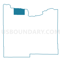
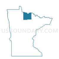
Manitou Sault Precinct, Koochiching County, Minnesota
About
Outline

Summary
| Unique Area Identifier | 602812 |
| Name | Manitou Sault Precinct |
| County | Koochiching County |
| State | Minnesota |
| Area (square miles) | 82.45 |
| Land Area (square miles) | 81.62 |
| Water Area (square miles) | 0.83 |
| % of Land Area | 98.99 |
| % of Water Area | 1.01 |
| Latitude of the Internal Point | 48.59248290 |
| Longtitude of the Internal Point | -94.01940190 |
Maps

Graphs
Select a template below for downloading or customizing gragh for Manitou Sault Precinct, Koochiching County, Minnesota


Neighbors
Neighoring Voting District (by Name) Neighboring Voting District on the Map
- Indus Precinct, Koochiching County, MN
- Murphy Precinct, Koochiching County, MN
- Watrous Precinct, Koochiching County, MN
- West Koochiching Voting District, Koochiching County, MN