


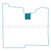
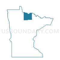
Reedy Precinct, Koochiching County, Minnesota
About
Outline

Summary
| Unique Area Identifier | 602810 |
| Name | Reedy Precinct |
| County | Koochiching County |
| State | Minnesota |
| Area (square miles) | 58.32 |
| Land Area (square miles) | 57.66 |
| Water Area (square miles) | 0.67 |
| % of Land Area | 98.85 |
| % of Water Area | 1.15 |
| Latitude of the Internal Point | 48.45687210 |
| Longtitude of the Internal Point | -93.66598620 |
Maps

Graphs
Select a template below for downloading or customizing gragh for Reedy Precinct, Koochiching County, Minnesota


Neighbors
Neighoring Voting District (by Name) Neighboring Voting District on the Map
- Koochiching Poll 5 Voting District, Koochiching County, MN
- Lindford Precinct, Koochiching County, MN
- Meadowbrook Precinct, Koochiching County, MN
- Scarlett Precinct, Koochiching County, MN
- Watrous Precinct, Koochiching County, MN
Top 10 Neighboring County Subdivision (by Population) Neighboring County Subdivision on the Map
- Rainy Lake UT, Koochiching County, MN (4,048)
- Northwest Koochiching UT, Koochiching County, MN (463)
- East Koochiching UT, Koochiching County, MN (355)
- South Koochiching UT, Koochiching County, MN (189)