


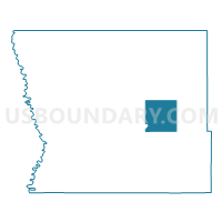
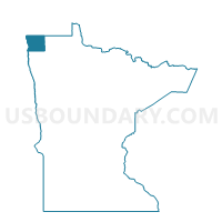
Percy Twp. Voting District, Kittson County, Minnesota
About
Outline

Summary
| Unique Area Identifier | 602769 |
| Name | Percy Twp. Voting District |
| County | Kittson County |
| State | Minnesota |
| Area (square miles) | 35.33 |
| Land Area (square miles) | 34.78 |
| Water Area (square miles) | 0.55 |
| % of Land Area | 98.46 |
| % of Water Area | 1.54 |
| Latitude of the Internal Point | 48.77029630 |
| Longtitude of the Internal Point | -96.60248420 |
Maps

Graphs
Select a template below for downloading or customizing gragh for Percy Twp. Voting District, Kittson County, Minnesota


Neighbors
Neighoring Voting District (by Name) Neighboring Voting District on the Map
- Cannon Twp. Voting District, Kittson County, MN
- Hazelton Twp. Voting District, Kittson County, MN
- Jupiter Twp. Voting District, Kittson County, MN
- Klondike Unorg. Voting District, Kittson County, MN
- Lake Bronson Voting District, Kittson County, MN
- Norway Twp. Voting District, Kittson County, MN
- Peatland Unorg. Voting District, Kittson County, MN
- Poppleton Twp. Voting District, Kittson County, MN
Top 10 Neighboring County Subdivision (by Population) Neighboring County Subdivision on the Map
- Lake Bronson city, Kittson County, MN (229)
- Poppleton township, Kittson County, MN (120)
- Jupiter township, Kittson County, MN (111)
- Hazelton township, Kittson County, MN (104)
- Norway township, Kittson County, MN (91)
- Percy township, Kittson County, MN (31)
- Cannon township, Kittson County, MN (20)
- Peatland UT, Kittson County, MN (9)
- Klondike UT, Kittson County, MN (0)