


St. Anthony P-2, Hennepin County, Minnesota
About
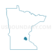
Outline

Summary
| Unique Area Identifier | 602078 |
| Name | St. Anthony P-2 |
| County | Hennepin County |
| State | Minnesota |
| Area (square miles) | 0.72 |
| Land Area (square miles) | 0.72 |
| Water Area (square miles) | 0.00 |
| % of Land Area | 100.00 |
| % of Water Area | 0.00 |
| Latitude of the Internal Point | 45.03003410 |
| Longtitude of the Internal Point | -93.21764890 |
Maps


Graphs
Select a template below for downloading or customizing gragh for St. Anthony P-2, Hennepin County, Minnesota


Neighbors
Neighoring Voting District (by Name) Neighboring Voting District on the Map
- Columbia Heights P-5, Anoka County, MN
- Minneapolis W-1 P-2, Hennepin County, MN
- Minneapolis W-1 P-3, Hennepin County, MN
- New Brighton P-1, Ramsey County, MN
- Roseville P-1, Ramsey County, MN
- St. Anthony P-1, Ramsey County, MN
- St. Anthony P-1, Hennepin County, MN
Top 10 Neighboring County Subdivision (by Population) Neighboring County Subdivision on the Map
- Minneapolis city, Hennepin County, MN (382,578)
- Roseville city, Ramsey County, MN (33,660)
- New Brighton city, Ramsey County, MN (21,456)
- Columbia Heights city, Anoka County, MN (19,496)
- St. Anthony city, Hennepin County, MN (5,156)
- St. Anthony city, Ramsey County, MN (3,070)
Top 10 Neighboring Place (by Population) Neighboring Place on the Map
- Minneapolis city, MN (382,578)
- Roseville city, MN (33,660)
- New Brighton city, MN (21,456)
- Columbia Heights city, MN (19,496)
- St. Anthony city, MN (8,226)
Top 10 Neighboring Unified School District (by Population) Neighboring Unified School District on the Map
- Minneapolis Public School District, MN (382,583)
- Mounds View Public School District, MN (74,050)
- Columbia Heights Public School District, MN (25,194)
- St. Anthony-New Brighton Schools, MN (9,846)
Top 10 Neighboring State Legislative District Lower Chamber (by Population) Neighboring State Legislative District Lower Chamber on the Map
- State House District 50A, MN (38,524)
- State House District 54A, MN (36,551)
- State House District 50B, MN (36,071)
- State House District 59A, MN (35,938)
Top 10 Neighboring State Legislative District Upper Chamber (by Population) Neighboring State Legislative District Upper Chamber on the Map
- State Senate District 59, MN (77,878)
- State Senate District 50, MN (74,595)
- State Senate District 54, MN (72,142)
Top 10 Neighboring 111th Congressional District (by Population) Neighboring 111th Congressional District on the Map
Top 10 Neighboring Census Tract (by Population) Neighboring Census Tract on the Map
- Census Tract 411.07, Ramsey County, MN (5,521)
- Census Tract 413.02, Ramsey County, MN (3,935)
- Census Tract 201.01, Hennepin County, MN (3,167)
- Census Tract 411.03, Ramsey County, MN (3,070)
- Census Tract 515.02, Anoka County, MN (2,893)
- Census Tract 6.03, Hennepin County, MN (2,749)
- Census Tract 201.02, Hennepin County, MN (1,989)