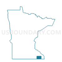
Peterson Voting District, Fillmore County, Minnesota
About
Outline

Summary
| Unique Area Identifier | 601963 |
| Name | Peterson Voting District |
| County | Fillmore County |
| State | Minnesota |
| Area (square miles) | 0.50 |
| Land Area (square miles) | 0.49 |
| Water Area (square miles) | 0.02 |
| % of Land Area | 96.41 |
| % of Water Area | 3.59 |
| Latitude of the Internal Point | 43.78769880 |
| Longtitude of the Internal Point | -91.83185490 |
Maps

Graphs
Select a template below for downloading or customizing gragh for Peterson Voting District, Fillmore County, Minnesota