


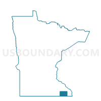
Chatfield Voting District, Fillmore County, Minnesota
About
Outline

Summary
| Unique Area Identifier | 601952 |
| Name | Chatfield Voting District |
| County | Fillmore County |
| State | Minnesota |
| Area (square miles) | 1.71 |
| Land Area (square miles) | 1.71 |
| Water Area (square miles) | 0.00 |
| % of Land Area | 100.00 |
| % of Water Area | 0.00 |
| Latitude of the Internal Point | 43.83968870 |
| Longtitude of the Internal Point | -92.18091930 |
Maps

Graphs
Select a template below for downloading or customizing gragh for Chatfield Voting District, Fillmore County, Minnesota


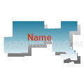


Neighbors
Neighoring Voting District (by Name) Neighboring Voting District on the Map
- Chatfield Voting District, Olmsted County, MN
- Chatfield Twp. Voting District, Fillmore County, MN
- Elmira Twp. Voting District, Olmsted County, MN
Top 10 Neighboring County Subdivision (by Population) Neighboring County Subdivision on the Map
- Chatfield city, Fillmore County, MN (1,573)
- Chatfield city, Olmsted County, MN (1,206)
- Chatfield township, Fillmore County, MN (531)
- Elmira township, Olmsted County, MN (354)