


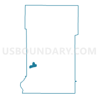
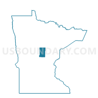
Baxter P-1E, Crow Wing County, Minnesota
About
Outline

Summary
| Unique Area Identifier | 601694 |
| Name | Baxter P-1E |
| County | Crow Wing County |
| State | Minnesota |
| Area (square miles) | 5.06 |
| Land Area (square miles) | 4.33 |
| Water Area (square miles) | 0.74 |
| % of Land Area | 85.48 |
| % of Water Area | 14.52 |
| Latitude of the Internal Point | 46.36117450 |
| Longtitude of the Internal Point | -94.25780510 |
Maps

Graphs
Select a template below for downloading or customizing gragh for Baxter P-1E, Crow Wing County, Minnesota


Neighbors
Neighoring Voting District (by Name) Neighboring Voting District on the Map
- Baxter P-1W, Crow Wing County, MN
- Baxter P-2E, Crow Wing County, MN
- Baxter P-2W, Crow Wing County, MN
- Brainerd W-2 P-1, Crow Wing County, MN
- White Prec., Crow Wing County, MN
Top 10 Neighboring County Subdivision (by Population) Neighboring County Subdivision on the Map
- Brainerd city, Crow Wing County, MN (13,590)
- Baxter city, Crow Wing County, MN (7,610)
- First Assessment UT, Crow Wing County, MN (5,424)
Top 10 Neighboring Place (by Population) Neighboring Place on the Map
Top 10 Neighboring Unified School District (by Population) Neighboring Unified School District on the Map
Top 10 Neighboring State Legislative District Lower Chamber (by Population) Neighboring State Legislative District Lower Chamber on the Map
Top 10 Neighboring State Legislative District Upper Chamber (by Population) Neighboring State Legislative District Upper Chamber on the Map
Top 10 Neighboring 111th Congressional District (by Population) Neighboring 111th Congressional District on the Map
Top 10 Neighboring Census Tract (by Population) Neighboring Census Tract on the Map
- Census Tract 9509, Crow Wing County, MN (5,331)
- Census Tract 9513.01, Crow Wing County, MN (4,702)
- Census Tract 9512, Crow Wing County, MN (2,659)