


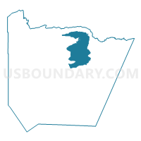
Colvill Prec. 3, Cook County, Minnesota
About
Outline

Summary
| Unique Area Identifier | 601597 |
| Name | Colvill Prec. 3 |
| County | Cook County |
| State | Minnesota |
| Area (square miles) | 179.79 |
| Land Area (square miles) | 168.67 |
| Water Area (square miles) | 11.12 |
| % of Land Area | 93.82 |
| % of Water Area | 6.18 |
| Latitude of the Internal Point | 47.91304560 |
| Longtitude of the Internal Point | -90.12936590 |
Maps


Graphs
Select a template below for downloading or customizing gragh for Colvill Prec. 3, Cook County, Minnesota


Neighbors
Neighoring Voting District (by Name) Neighboring Voting District on the Map
- Croftville Prec. 4, Cook County, MN
- Hovland Prec. 2, Cook County, MN
- Maple Hill Prec. 8, Cook County, MN
- Voting Districts not defined, Cook County, MN
Top 10 Neighboring County Subdivision (by Population) Neighboring County Subdivision on the Map
- West Cook UT, Cook County, MN (1,616)
- East Cook UT, Cook County, MN (775)
- County subdivisions not defined, Cook County, MN (0)