


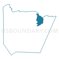
Hovland Prec. 2, Cook County, Minnesota
About
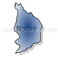
Outline

Summary
| Unique Area Identifier | 601596 |
| Name | Hovland Prec. 2 |
| County | Cook County |
| State | Minnesota |
| Area (square miles) | 98.23 |
| Land Area (square miles) | 96.98 |
| Water Area (square miles) | 1.25 |
| % of Land Area | 98.72 |
| % of Water Area | 1.28 |
| Latitude of the Internal Point | 47.92902690 |
| Longtitude of the Internal Point | -89.95684970 |
Maps


Graphs
Select a template below for downloading or customizing gragh for Hovland Prec. 2, Cook County, Minnesota


Neighbors
Neighoring Voting District (by Name) Neighboring Voting District on the Map
- Colvill Prec. 3, Cook County, MN
- Grand Portage Prec. 1, Cook County, MN
- Maple Hill Prec. 8, Cook County, MN
- Voting Districts not defined, Cook County, MN
Top 10 Neighboring County Subdivision (by Population) Neighboring County Subdivision on the Map
- East Cook UT, Cook County, MN (775)
- Grand Portage UT, Cook County, MN (565)
- County subdivisions not defined, Cook County, MN (0)