


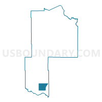
Fairview Twp. Voting District, Cass County, Minnesota
About
Outline

Summary
| Unique Area Identifier | 601461 |
| Name | Fairview Twp. Voting District |
| County | Cass County |
| State | Minnesota |
| Area (square miles) | 39.94 |
| Land Area (square miles) | 35.63 |
| Water Area (square miles) | 4.32 |
| % of Land Area | 89.19 |
| % of Water Area | 10.81 |
| Latitude of the Internal Point | 46.41782520 |
| Longtitude of the Internal Point | -94.43708030 |
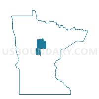
Maps

Graphs
Select a template below for downloading or customizing gragh for Fairview Twp. Voting District, Cass County, Minnesota


Neighbors
Neighoring Voting District (by Name) Neighboring Voting District on the Map
- East Gull Lake Voting District, Cass County, MN
- Homebrook Twp. Voting District, Cass County, MN
- Lake Shore Voting District, Cass County, MN
- May Twp. Voting District, Cass County, MN
- Meadowbrook Twp. Voting District, Cass County, MN
- Sylvan Twp. Voting District, Cass County, MN
Top 10 Neighboring County Subdivision (by Population) Neighboring County Subdivision on the Map
- Sylvan township, Cass County, MN (2,702)
- East Gull Lake city, Cass County, MN (1,004)
- Lake Shore city, Cass County, MN (1,004)
- May township, Cass County, MN (852)
- Fairview township, Cass County, MN (821)
- Home Brook township, Cass County, MN (255)
- Meadow Brook township, Cass County, MN (226)
Top 10 Neighboring Place (by Population) Neighboring Place on the Map
Top 10 Neighboring Unified School District (by Population) Neighboring Unified School District on the Map
- Brainerd Public School District, MN (42,588)
- Staples-Motley School District, MN (10,060)
- Pillager Public School District, MN (5,216)