


Toad Lake Twp. Voting District, Becker County, Minnesota
About
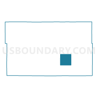
Outline

Summary
| Unique Area Identifier | 601105 |
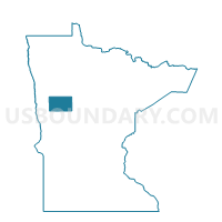
| Name | Toad Lake Twp. Voting District |
| County | Becker County |
| State | Minnesota |
| Area (square miles) | 36.31 |
| Land Area (square miles) | 32.92 |
| Water Area (square miles) | 3.39 |
| % of Land Area | 90.66 |
| % of Water Area | 9.34 |
| Latitude of the Internal Point | 46.85378510 |
| Longtitude of the Internal Point | -95.45837070 |
Maps

Graphs
Select a template below for downloading or customizing gragh for Toad Lake Twp. Voting District, Becker County, Minnesota


Neighbors
Neighoring Voting District (by Name) Neighboring Voting District on the Map
- Carsonville Twp. Voting District, Becker County, MN
- Evergreen Twp. Voting District, Becker County, MN
- Height Of Land Twp. Voting District, Becker County, MN
- Shell Lake Twp. Voting District, Becker County, MN
- Silver Leaf Twp. Voting District, Becker County, MN
- Spruce Grove Twp. Voting District, Becker County, MN
- Wolf Lake Twp. Voting District, Becker County, MN
Top 10 Neighboring County Subdivision (by Population) Neighboring County Subdivision on the Map
- Height of Land township, Becker County, MN (673)
- Toad Lake township, Becker County, MN (539)
- Silver Leaf township, Becker County, MN (534)
- Spruce Grove township, Becker County, MN (405)
- Evergreen township, Becker County, MN (340)
- Shell Lake township, Becker County, MN (293)
- Wolf Lake township, Becker County, MN (242)
- Carsonville township, Becker County, MN (220)
Top 10 Neighboring Unified School District (by Population) Neighboring Unified School District on the Map
- Park Rapids Public School District, MN (12,088)
- Frazee-Vergas Public School District, MN (6,964)
- Menahga Public School District, MN (3,617)