


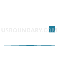
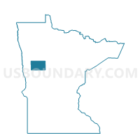
Osage Twp. Voting District, Becker County, Minnesota
About
Outline

Summary
| Unique Area Identifier | 601092 |
| Name | Osage Twp. Voting District |
| County | Becker County |
| State | Minnesota |
| Area (square miles) | 35.87 |
| Land Area (square miles) | 34.96 |
| Water Area (square miles) | 0.91 |
| % of Land Area | 97.46 |
| % of Water Area | 2.54 |
| Latitude of the Internal Point | 46.92770300 |
| Longtitude of the Internal Point | -95.21570970 |
Maps

Graphs
Select a template below for downloading or customizing gragh for Osage Twp. Voting District, Becker County, Minnesota


Neighbors
Neighoring Voting District (by Name) Neighboring Voting District on the Map
- Arago Twp. Voting District, Hubbard County, MN
- Carsonville Twp. Voting District, Becker County, MN
- Green Valley Twp. Voting District, Becker County, MN
- Straight River Twp. Voting District, Hubbard County, MN
- Todd Twp. P-1, Hubbard County, MN
- Two Inlets Twp. Voting District, Becker County, MN
- Wolf Lake Twp. Voting District, Becker County, MN
Top 10 Neighboring County Subdivision (by Population) Neighboring County Subdivision on the Map
- Todd township, Hubbard County, MN (1,393)
- Osage township, Becker County, MN (895)
- Straight River township, Hubbard County, MN (726)
- Arago township, Hubbard County, MN (607)
- Green Valley township, Becker County, MN (376)
- Wolf Lake township, Becker County, MN (242)
- Carsonville township, Becker County, MN (220)
- Two Inlets township, Becker County, MN (213)
Top 10 Neighboring Place (by Population) Neighboring Place on the Map
Top 10 Neighboring Unified School District (by Population) Neighboring Unified School District on the Map
Top 10 Neighboring State Legislative District Lower Chamber (by Population) Neighboring State Legislative District Lower Chamber on the Map
- State House District 2B, MN (39,744)
- State House District 10B, MN (37,598)
- State House District 2A, MN (37,063)