


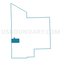
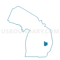
Voting District 1572160000002, Tuscola County, Michigan
About
Outline

Summary
| Unique Area Identifier | 599617 |
| Name | Voting District 1572160000002 |
| County | Tuscola County |
| State | Michigan |
| Area (square miles) | 18.33 |
| Land Area (square miles) | 18.33 |
| Water Area (square miles) | 0.00 |
| % of Land Area | 100.00 |
| % of Water Area | 0.00 |
| Latitude of the Internal Point | 43.41560480 |
| Longtitude of the Internal Point | -83.64006320 |
Maps

Graphs
Select a template below for downloading or customizing gragh for Voting District 1572160000002, Tuscola County, Michigan


Neighbors
Neighoring Voting District (by Name) Neighboring Voting District on the Map
- Voting District 1450940000001, Saginaw County, MI
- Voting District 1453022000001, Saginaw County, MI
- Voting District 1572160000001, Tuscola County, MI
- Voting District 1574214000001, Tuscola County, MI
- Voting District 1578094000001, Tuscola County, MI
- Voting District 1578186000001, Tuscola County, MI
Top 10 Neighboring County Subdivision (by Population) Neighboring County Subdivision on the Map
- Vassar township, Tuscola County, MI (4,093)
- Denmark township, Tuscola County, MI (3,068)
- Tuscola township, Tuscola County, MI (2,082)
- Blumfield township, Saginaw County, MI (1,960)
- Frankenmuth township, Saginaw County, MI (1,959)
- Juniata township, Tuscola County, MI (1,567)
Top 10 Neighboring Unified School District (by Population) Neighboring Unified School District on the Map
- Frankenmuth School District, MI (9,277)
- Vassar Public Schools, MI (9,206)
- Reese Public Schools, MI (5,494)
Top 10 Neighboring State Legislative District Lower Chamber (by Population) Neighboring State Legislative District Lower Chamber on the Map
Top 10 Neighboring State Legislative District Upper Chamber (by Population) Neighboring State Legislative District Upper Chamber on the Map
Top 10 Neighboring 111th Congressional District (by Population) Neighboring 111th Congressional District on the Map
Top 10 Neighboring Census Tract (by Population) Neighboring Census Tract on the Map
- Census Tract 113, Saginaw County, MI (6,903)
- Census Tract 9, Tuscola County, MI (5,311)
- Census Tract 8, Tuscola County, MI (3,987)
- Census Tract 7, Tuscola County, MI (3,627)
- Census Tract 112, Saginaw County, MI (1,960)