


Voting Districts not defined, Tuscola County, Michigan
About
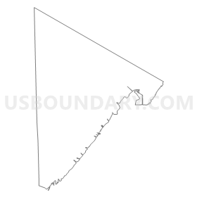
Outline
Summary
| Unique Area Identifier | 599600 |
| Name | Voting Districts not defined |
| County | Tuscola County |
| State | Michigan |
| Area (square miles) | 99.80 |
| Land Area (square miles) | 0.00 |
| Water Area (square miles) | 99.80 |
| % of Land Area | 0.00 |
| % of Water Area | 100.00 |
| Latitude of the Internal Point | 43.72531210 |
| Longtitude of the Internal Point | -83.47005600 |
Maps

Graphs
Select a template below for downloading or customizing gragh for Voting Districts not defined, Tuscola County, Michigan


Neighbors
Neighoring Voting District (by Name) Neighboring Voting District on the Map
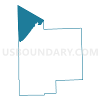
- Voting District 0173626000005, Bay County, MI
- Voting District 0637220000001, Huron County, MI
- Voting District 1570072000001, Tuscola County, MI
- Voting District 1578808000001, Tuscola County, MI
- Voting Districts not defined, Huron County, MI
- Voting Districts not defined, Bay County, MI
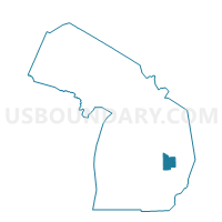
Top 10 Neighboring County Subdivision (by Population) Neighboring County Subdivision on the Map
- Hampton charter township, Bay County, MI (9,652)
- Sebewaing township, Huron County, MI (2,724)
- Akron township, Tuscola County, MI (1,503)
- Fairhaven township, Huron County, MI (1,107)
- Wisner township, Tuscola County, MI (690)
- County subdivisions not defined, Bay County, MI (0)
- County subdivisions not defined, Tuscola County, MI (0)
Top 10 Neighboring Place (by Population) Neighboring Place on the Map
Top 10 Neighboring Unified School District (by Population) Neighboring Unified School District on the Map
- Essexville-Hampton Public Schools, MI (8,785)
- Unionville-Sebewaing Area School District, MI (5,531)
- Akron-Fairgrove Schools, MI (3,011)
- School District Not Defined (Water), MI (243)
Top 10 Neighboring State Legislative District Lower Chamber (by Population) Neighboring State Legislative District Lower Chamber on the Map
Top 10 Neighboring State Legislative District Upper Chamber (by Population) Neighboring State Legislative District Upper Chamber on the Map
Top 10 Neighboring 111th Congressional District (by Population) Neighboring 111th Congressional District on the Map
Top 10 Neighboring Census Tract (by Population) Neighboring Census Tract on the Map
- Census Tract 2852.01, Bay County, MI (5,834)
- Census Tract 2852.02, Bay County, MI (3,818)
- Census Tract 9508, Huron County, MI (3,484)
- Census Tract 2, Tuscola County, MI (3,245)
- Census Tract 3, Tuscola County, MI (3,218)
- Census Tract 9900, Huron County, MI (0)
- Census Tract 9900, Bay County, MI (0)
- Census Tract 9900, Tuscola County, MI (0)