


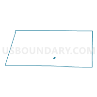
Voting District 1015072000002, Manistee County, Michigan
About
Outline

Summary
| Unique Area Identifier | 598154 |
| Name | Voting District 1015072000002 |
| County | Manistee County |
| State | Michigan |
| Area (square miles) | 0.84 |
| Land Area (square miles) | 0.81 |
| Water Area (square miles) | 0.03 |
| % of Land Area | 96.95 |
| % of Water Area | 3.05 |
| Latitude of the Internal Point | 44.25620710 |
| Longtitude of the Internal Point | -86.32480090 |
Maps

Graphs
Select a template below for downloading or customizing gragh for Voting District 1015072000002, Manistee County, Michigan


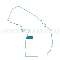
Neighbors
Neighoring Voting District (by Name) Neighboring Voting District on the Map
- Voting District 1015072000003, Manistee County, MI
- Voting District 1015072000004, Manistee County, MI
- Voting District 1015072000005, Manistee County, MI
- Voting District 1015074000001, Manistee County, MI
- Voting Districts not defined, Manistee County, MI
Top 10 Neighboring County Subdivision (by Population) Neighboring County Subdivision on the Map
- Manistee city, Manistee County, MI (6,226)
- Manistee township, Manistee County, MI (4,084)
- County subdivisions not defined, Manistee County, MI (0)