


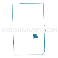
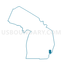
Voting District 0993682000010, Macomb County, Michigan
About
Outline

Summary
| Unique Area Identifier | 598032 |
| Name | Voting District 0993682000010 |
| County | Macomb County |
| State | Michigan |
| Area (square miles) | 5.13 |
| Land Area (square miles) | 5.13 |
| Water Area (square miles) | 0.00 |
| % of Land Area | 99.94 |
| % of Water Area | 0.06 |
| Latitude of the Internal Point | 42.61224830 |
| Longtitude of the Internal Point | -82.83245270 |
Maps

Graphs
Select a template below for downloading or customizing gragh for Voting District 0993682000010, Macomb County, Michigan


Neighbors
Neighoring Voting District (by Name) Neighboring Voting District on the Map
- Voting District 0991534000003, Macomb County, MI
- Voting District 0991652000028, Macomb County, MI
- Voting District 0993682000009, Macomb County, MI
- Voting District 0995048000002, Macomb County, MI
- Voting District 0995582000005, Macomb County, MI
- Voting District 09936820, Macomb County, MI
- Voting Districts not defined, Macomb County, MI
Top 10 Neighboring County Subdivision (by Population) Neighboring County Subdivision on the Map
- Clinton charter township, Macomb County, MI (96,796)
- Macomb township, Macomb County, MI (79,580)
- Chesterfield township, Macomb County, MI (43,381)
- Harrison charter township, Macomb County, MI (24,587)
- Mount Clemens city, Macomb County, MI (16,314)
Top 10 Neighboring Place (by Population) Neighboring Place on the Map
Top 10 Neighboring Unified School District (by Population) Neighboring Unified School District on the Map
- L'Anse Creuse Public Schools, MI (68,985)
- Mount Clemens Community School District, MI (21,347)
- School District Not Defined (Water), MI (243)
Top 10 Neighboring State Legislative District Lower Chamber (by Population) Neighboring State Legislative District Lower Chamber on the Map
- State House District 33, MI (119,064)
- State House District 32, MI (103,394)
- State House District 31, MI (86,265)
- State House District 24, MI (84,381)
Top 10 Neighboring State Legislative District Upper Chamber (by Population) Neighboring State Legislative District Upper Chamber on the Map
- State Senate District 11, MI (313,398)
- State Senate District 10, MI (278,551)
- State Senate District 9, MI (249,029)
Top 10 Neighboring 111th Congressional District (by Population) Neighboring 111th Congressional District on the Map
Top 10 Neighboring Census Tract (by Population) Neighboring Census Tract on the Map
- Census Tract 2234, Macomb County, MI (8,630)
- Census Tract 2211, Macomb County, MI (6,792)
- Census Tract 2472, Macomb County, MI (6,654)
- Census Tract 2473, Macomb County, MI (6,365)
- Census Tract 2682, Macomb County, MI (3,922)
- Census Tract 2400, Macomb County, MI (3,809)
- Census Tract 2450, Macomb County, MI (3,364)
- Census Tract 2471, Macomb County, MI (1,037)
- Census Tract 9821, Macomb County, MI (0)
Top 10 Neighboring 5-Digit ZIP Code Tabulation Area (by Population) Neighboring 5-Digit ZIP Code Tabulation Area on the Map
- 48047, MI (39,415)
- 48042, MI (27,291)
- 48045, MI (24,604)
- 48036, MI (20,980)
- 48051, MI (17,319)
- 48043, MI (16,305)